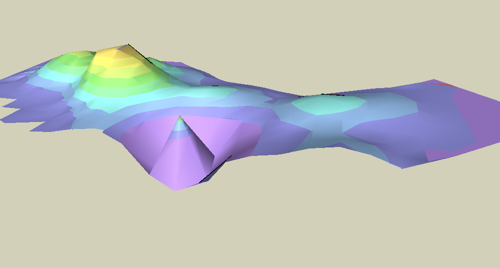
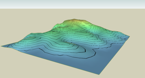
Contour lines on irregular surface
-
Does a ruby do this? Place topographic contour lines ? Perhaps it would be more correct if the lines (with coloring or not) were made with a texture, but I wonder if that's possible?
-
Its fairly easy to do this by hand, if you want to.
The easiest way is to just use a texture, side on to the terrain, which is just a graduated series of colours. You can then project it on to the terrain.
-
Thanks, I'll try that. I did the above with an array of planes and intersect.
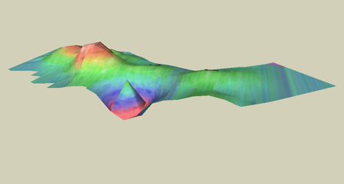
OK, I tried it. Yay SU!
I expected to find a clean gradient on the web. As you can see I found a texture that wasn't tiled well and I got one with a rough pattern which adds to the streakiness. I could probably make one in PS that's much cleaner, but I don't have PS.
-
It could be done with a Ruby just using a series of horizontal planes to cut the topographic surface at given altitudes.
This will allow to generate the contour lines, by constructing the intersections.
then, you color each face of the topographic surface based on finding out for each face which horizontal planes it is in between.Certainly some good use of CPU, but nothing too complex in terms of coding.
As an input, you would need
- the topographic surface (as a selection of face or group or components)
- a master plane (probably the horizontal plane), given by a normal vector
- an origin and a pace to generate the series of planes
- a color list (or scheme to change the color) along with the series of plane and pace
Fredo
-
Hi,
@unknownuser said:
This will allow to generate the contour lines, by constructing the intersections.
then, you color each face of the topographic surface based on finding out for each face which horizontal planes it is in between.I wrote several scripts to do that a while ago. Search for "contour" on my site and "paint altitude faces".
Regards, -
OK thanks a million!
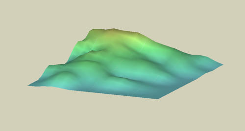
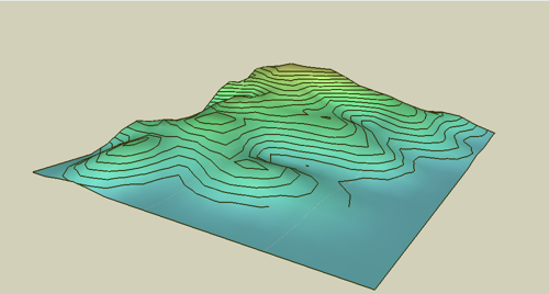
Here's a landform with a better texture I made...
Here's one with lines in the texture. As you can see the result is not as nice as interstecting the shape with planes.
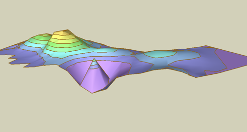
This one is using intersect with planes but using a copy and overlaying the resulting lines so the earth form isn't affected.
Now to see what Didier hath wrought.
-
Fredo,
Just having done both methods, it seems to me that the texture would be better, so that you do not compromise the geometry of your shape. You could then revise the shape and have the topographic pattern adjust. The trick of a ruby would be a well dimensioned (in the case of contours), scaled, and standardized texture. Choices of contours and colors or both would be nice. Choice of scale, for lot-sized grading plans versus mountain-sized maps, would be good. The contour intervals and colors would be adjusted for each.
I began to think of this from a gallery house site render that used a simple colored ground with topographic contours. It was an effective way to finish the image without a lot of texture and entourage. Subtle color change would have been nice too (not rainbow colors as I show here).
Peter
-
Peter,
Sorry I didn't catch this discussion earlier. Any help here?
Terrain Tech - Google 3D WarehouseTaff
-
@taffgoch said:
Peter,
Sorry I didn't catch this discussion earlier. Any help here?
Terrain Tech - Google 3D WarehouseTaff
Taff
Wow, beautiful looking models / demonstrations. Thanks for the post! How do you generate the terrain in the Palo Duro and Panther Creek models?
Peter
-
Didier,
I get this message:
Error Loading File contour_lines.rb
undefined method `file_loaded?' for main:ObjectPeter
-
You have to add this line in the Ruby file (if you have access..) :
require "sketchup.rb" -
Thanks. I did look at another file and searched for a likely header. I suspected this was part of it, from the little messing around I've done with simple files like DXF before. I'll try that.
Peter
-
-
@pbacot said:
How do you generate the terrain in the Palo Duro and Panther Creek models?"
Peter,
I download USGS DEM data files from the GIS Data Depot, to start.
SketchUp can import DEM files, but they're HUGE! I import them into TerraGen, and select the portion of the topographic map in which I'm interested, sub-sample (simply) the data, and export as a DXF file. These steps reduce the complexity of the mesh data, and produce a much more reasonably-sized data file for SketchUp to import. (TerraGen is free, as are a couple of plugins required to do the DXF stuff.)
Once you've done it a few times, it goes pretty quickly. (By the way, topographic map imagery can also be downloaded from the GIS Data Depot.)
Taff
-
TIG,
I tried yours and it seems to work great for what I was doing (rather than duplicating planes and intersecting "by hand"). Also gives the lines as a separate group, instead of making them part of the mesh, which I like.
Taff,
I think your ruby will do the same thing once I fix the header. I am not sure the paint faces ruby works for the effect I was looking for, as it does not give a graduated texture, nor colors by contour. It might be useful if the model is used in analysis. I only got one color, though I picked other ones. It has an interesting look, like an iceberg. Just for your info (not complaining) where you put in a number (default 10) is is not clear what the number is and that there is a limit, seems to be about 46). The lower numbers give a very subtle effect. If you go too hight the colors repeat, starting with the dark color.Your terrain models are very helpful (wish SU were faster in flying over).It would be neat to do the model of a place you are going to visit and hike in. And I like the effect you got with the lake surface.
Thank you both for the help.
Peter
Hello! It looks like you're interested in this conversation, but you don't have an account yet.
Getting fed up of having to scroll through the same posts each visit? When you register for an account, you'll always come back to exactly where you were before, and choose to be notified of new replies (either via email, or push notification). You'll also be able to save bookmarks and upvote posts to show your appreciation to other community members.
With your input, this post could be even better 💗
Register Login


Advertisement