Understanding xyz coordinates
-
I have a model i need to put in established xyz coordinates so the points can be located by survey. The coordinates are big numbers and the system is used for a large area that includes a power plant. To start modeling at the correct point, i drew a line from 0,0,0 using the [x,y,z] system. Then i started cutting and pasting the components to that know position. To determine the coordinates i selected label and pointed to the location. the lines drawn from the origin to a coordinate display that coordinate. using the label tool and selecting a point on the drawn geometry don't locate correctly. I have spent quite a lot of time trying to understand it. Attached is a very simplified version of what i'm trying to do. lines drawn from the origin to the corners label correctly. labels on the drawn geometry are incorrect. I can add more components if it helps.
thanks, Pat
-
Your model geometry is located too far (approx 300 miles) from the SketchUp model origin, which will cause the kinds of issues you are seeing. There are several possibilities to deal with this:
- geolocate the model and use coordinates relative to the geolocation origin
- move the contents to the model origin by selecting all of it, starting the move tool, and then entering [0,0,0] (which represents an absolute move to the model origin)
- subtract the distance to the model origin from each of your coordinates before you draw (yes, a pain!).
-
@slbaumgartner said:
Your model geometry is located too far (approx 300 miles) from the SketchUp model origin, which will cause the kinds of issues you are seeing. There are several possibilities to deal with this:
- geolocate the model and use coordinates relative to the geolocation origin
- move the contents to the model origin by selecting all of it, starting the move tool, and then entering [0,0,0] (which represents an absolute move to the model origin)
- subtract the distance to the model origin from each of your coordinates before you draw (yes, a pain!).
I don't think the distance from the origin is the issue. I think it's the ability to determine the location. I have played with it some more and if I label a coordinate that is in a group the coordinates are fouled up. If i draw a line that is not in a group i can label the end correctly. It's hard to get it to label properly this way it changes to "enter text." new file uploaded. I use autocad and it has a box when you hover over a point it will give the coordinates and it is also part of the properties. I think I just need help determining the coordinates of the point different than using the label tool.
PAT
-
You need to realize that there are multiple coordinate systems in action within SketchUp. Every component definition specifies the location of its points with reference to its own local coordinates. If the points are within a sensible distance of the local coordinate origin, there are no issues internal to the definition. But when an instance of that definition is placed in the model, the locations are transformed from the definition's local coordinates to the model's global coordinates. In your case, this amounts to adding about 1676890 inches (over 300 miles) to the location of every vertex. That large offset consumes almost all of the available precision in the internal representation, causing relatively small differences to be lost to underflow when you deal with the model. The effects start to be serious at about 30 miles from the model origin.
-
thanks for looking at this. I have played around with it and i get the same issue if i work close to the origin. If i label a coordinate that is in a group it has a different coordinate than if it is not in a group. It must pick up some coordinate system internal to a group. There must be a way of determining the xyz coordinate of any location other than the labeling tool.
-
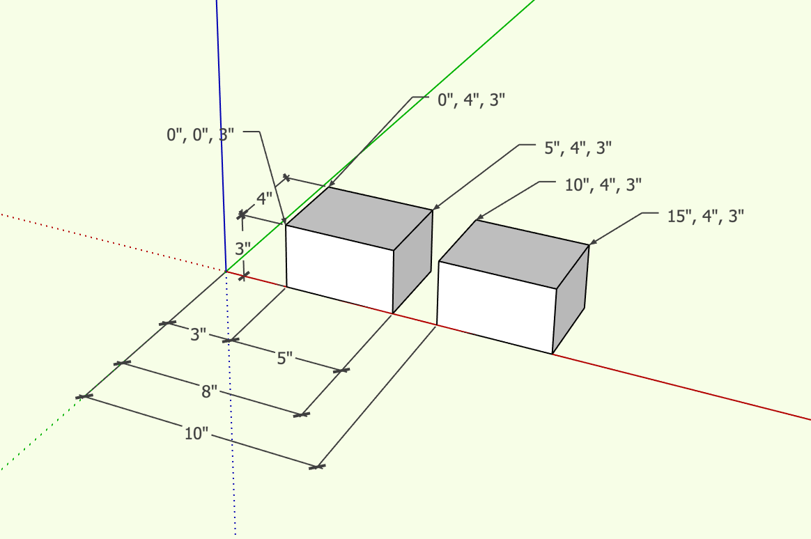
There seems to be either strange semantics or an outright bug in the label text tool applied to vertices in groups. The displayed coordinates seem to be reversed from what I would expect! In the attached screenshot, I created a 5x4x3 group at the origin, moved a copy 3 along the red axis, and then a second copy 2 more. Then I labeled vertices in the copy nearer to the origin without opening it for edit. The coordinates displayed are the ones for the vertices in the group's component definition's coordinates despite the fact that the group is not open for edit! I would have expected model coordinates. Then I opened the right-most copy for edit and labeled vertices within the group. These labels display the locations in the model's global coordinates, when I would have expected definition coordinates!
Equally strange, if the objects are components instead of groups, I can't even label vertices without opening for edit. Instead, the label tool displays the instance name (or definition name if the instance name is blank) of the component!
So, no wonder you are getting confused when using this tool on groups and components!
-
Yes, it's odd. I did find there is a Utilities plug in that includes create face and a query tool. The query tool seems to get it correct. I don't think you can capture the data and label the drawing with it, but it does display the xyz coordinates. We didn't get much interest in this topic. I would have thought many would have a problem finding locations in space.
Pat
Hello! It looks like you're interested in this conversation, but you don't have an account yet.
Getting fed up of having to scroll through the same posts each visit? When you register for an account, you'll always come back to exactly where you were before, and choose to be notified of new replies (either via email, or push notification). You'll also be able to save bookmarks and upvote posts to show your appreciation to other community members.
With your input, this post could be even better 💗
Register Login


Advertisement