Bringing Satellite and Terrain back with Twilight Render
-
When the 5 year agreement between Google and Trimble expired, leaving SketchUp Make users without a way to download satellite imagery and terrain, it left a pretty painful hole in a lot of users' workflow. It has been discussed here at SketchUcation and is pretty obvious to anyone who has tried to use the feature in the last few months!
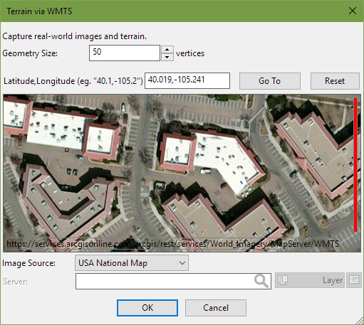
As we have been expanding Twilight Render to bring in new features, and had already added a Terrain editing tool, we wanted to do something about bringing satellite and elevation data back to SketchUp. It's taken a little while but we have released Twilight Render V2.10 with a major update to our Terrain Tools AddOn that brings satellite and terrain back to SketchUp (and all from publicly available datasources!).
You can see it on our homepage (https://www.twilightrender.com), our announcement on our user forum and read all about it in our updated Terrain Tools Tutorial.

For those of you unfamiliar with Twilight Render, we are an affordable rendering plugin for SketchUp, have been around for over 8 years, and are continuously developing and improving our product. The Terrain Tool editing tool requires a license for Twilight Render Pro and a purchase of the Terrain Tool AddOn package.
-
what are the
@twilightrender said:...publicly available datasources...
and which areas do they cover?
-
The coverage is global, but obviously with varying levels of detail depending on the area. For the US and Europe the coverage is very good. For other areas, urban will have better resolution.
All the data is retrieved from online WMS and WMTS servers. Which server is used depends on the area, and users are able to connect to their own custom server (for example, if a you have a paid service with a GIS imagery provider). The tool does not include any dataset directly, but it connects the user to a 'recommended' server based on the area of interest (and again, you can choose to connect to any server you want by choosing the 'Custom' option). The list of recommended servers include NASA, USGS, Discomap EEA, Terrestris, EOX, ArcGIS Online, and others. (Note it does not utilize Google or Bing maps; though those maps are of high quality, they also come with too many restrictions.)
-
Too bad it isn't available for users that don't use Twilight. Why not a standalone SU plugin as an option?
-
We could look into that, definitely. At a guess, there shouldn't be any technical reasons that couldn't be done.
-
Twilight is so affordable. They can't give this stuff away. Just buy it and get renderer. terrain editor, satellite data, NPR rendering with SU overlay etc.
-
I used Twilight Render ages ago. It is a nice fast straight-out-of-SU solution. This may make it worth looking into again. I've been sorely missing the old GE topo import.
-
@pixero said:
Too bad it isn't available for users that don't use Twilight. Why not a standalone SU plugin as an option?
+1 on this
-
TWL Pro costs $99 with continuous updates and support--adding features without charging current users, and not upping the price. How can anyone make any money at that rate?
OK, maybe if they offered a $25 plugin they'd get more people in, enough to make it pay off.
-
I think I have an old license but that is not the issue.
I don't want to install it if I am not going to use it just to be able to use that function.
Advertisement


