Draping roads, parking, etc ONTO a TIN?
-
Hi all. I'm familiar with Sandbox/Drape and SuperDrape by TIG.
Drape essentially takes a flat surface (a road shape in 2D for example) and projects it down onto the surface of a TIN. When it does so it CUTS the surface of the TIN. Once this happens it becomes very difficult to control materials and layers...all pertinent faces have to be regrouped, applied to a specific layer and have the correct materials re-applied. (You can't simply "paint" materials onto segments of the TIN "skin" if you need to control layers on/off.)Instead, is there a way to take that 2D road, and project it downward ONTO (not IN) the TIN. Ideally it takes the road group and "pushes" it onto the TIN but still remains it's own group. In this way all the 2D work can "coexist" next to each other on the TIN, and the same layers and materials still work.
Ideas?
-
Not sure this plug-in will work for you but take a look.
-
I'm not sure, but I think you are talking about Stamp- one of the Sketchup Sandbox Tools. Unless the alteration of the TIN cancels whatever materials/textures you have already applied. The road should be a group or component before the stamping procedure. I presume it can have its own textures and materials. Same with the TIN. Drape and Superdrape are different. Instant Road by valiarchitects is a good tool, also.
-
Maybe an intersection as a workaround?
(used plugins: JPP and Curviloft)

-
I understand Vali's Instant Road, and how to drape. Those emthods actually interact and "cut" the TIN of the google earth terrain. That's not what I'm after.
I'll try to be clearer...I'm doing a site concept presentation. I have 2D sketchup site diagrams all worked out; roads, parking. fields, wetland zones, buffer zones, etc. And all of these are on separate layers with separate materials/colors applied. So, in the presentation I want to show the whole site with just my roads and the property line as slide/scene 1. Then scene 2 adds easements, then scene 3 adds wetlands, then scene 4 adds buffer zones, etc...until I build, really , a GIS image with all factors. Ok, easy enough in 2d.
Now, I want to get all of that 2D stuff ONTO the google earth terrain.
I don't want to actually put this stuff INTO the TIN, and have the TIN cut by the actual road, etc. Using that method I would have a very difficult time controlling stuff on layers being turned on and off. The wetlands geometry would share a boundary with the road geometry, and then when I wanted to view the site without the wetlands info, for example, there are big holes in the terrain TIN because that "layer"/geometry is turned off. I don't need to actually model terrain/earthwork, and create roads, berms, etc. I just need to get that 2D diagram stuff draped ON TOP OF the terrain without interacting with it in any way. The diagram roads, parking, wetland areas are totally independent of the google earth terrain. They just lay perfectly on top of it.Any ideas? Thanks.
-
-
You can copy a second version of the terrain and drape onto that. If you show both the terrain and your draped road etc. there will be z-fighting unless you raise the latter up a little. I can't see how you can achieve this easily with your layers. You'd have to take your second terrain, drape onto it. Project the textures of the drape, place that drape portion onto it's respective layer, setup the scene etc.
-
It doesn't have to be fully manual.
If your terrain is all smooth, you can drape in the terrain copy and the select the surfaces inside the drape lines with one click.
Then it's just a matter of grouping everyone of this drapes and layer/scene organization. Pretty quick if you ask me.
JQL
-
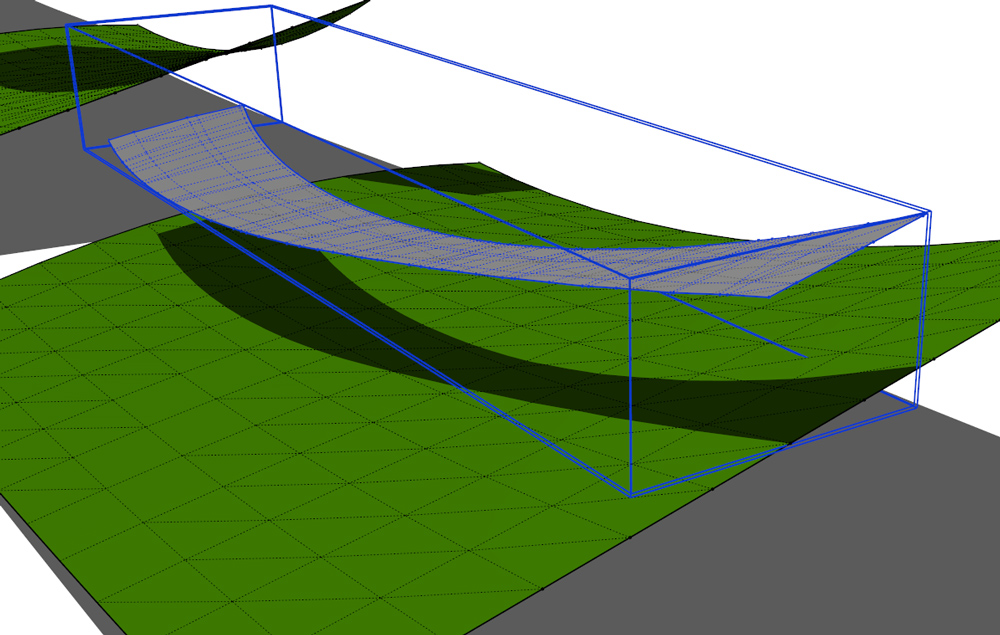
@cotty said:
I'll try to be clearer, too

(if a step in the SU-file is not clear, let me know...)Ahhh! Yes! When the extrusion/intersect method was mentioned I imagined the intersection CUTTING the terrain TIN. I have to play with intersection tool to allow the intersection content to be OUTSIDE of the TIN group. Apparently that's what you have done here.
Although it's fully-manual, this will be a pretty effective solution...thanks!

OK, well, I've tried this method on a simple model.
skp file attached
What I find is that I get the intersection as individual lines (not in a group), and without the geometry being "skinned" into a TIM.Is there a method of intersection that results in a "skinned" TIN group???
PS, to attach an image, is there a way to browse to my hard drive for it? Or does it have to be in the cloud as Photobucket, etc?
-
@jql said:
It doesn't have to be fully manual.
If your terrain is all smooth, you can drape in the terrain copy and the select the surfaces inside the drape lines with one click.
Then it's just a matter of grouping everyone of this drapes and layer/scene organization. Pretty quick if you ask me.
JQL
Maybe I'm missing something. It seems a bit finicky to me.
If you drape everything onto a copy of the terrain, and then group and re-layer the individual pieces, what do you do about adjacent items that will share the same edges? And example would be a sidewalk right against a road and a parking area right alongside the sidewalk. One you grouped the sidewalk, the road and the parking have both lost an edge. You'd need to go into the sidewalk, copy out that common edge lines, then go back to the road group, and Past in Place. And do that for each group that shares a common boundary with another group. Right? Or have a whole series of terrains stacked down on the z-axis, and drape each of the above elements to a terrain such that no "drapes" will be adjacent. -
No its not right. If you select the surface with one click (or double click to be sure)inside one of those "drape zones" and then you just group it, the group will be created and the commong edges will be kept, so they don't destroy other surfaces.
It's pretty easy... just test it once and you'll see.
JQL
-
@jql said:
No its not right. If you select the surface with one click (or double click to be sure)inside one of those "drape zones" and then you just group it, the group will be created and the commong edges will be kept, so they don't destroy other surfaces.
It's pretty easy... just test it once and you'll see.
JQL
Thanks! You're right! Another case of my old brain making things more complicated then they are.
-
@cotty: how are you able to fill in the intersect profile shape? or, how did you fill the new intersected road to make it solid? danke
-
@cotty said:
I'll try to be clearer, too
(if a step in the SU-file is not clear, let me know...)how are you able to fill the intersected lines to get you from the non filled outline in step 3 of your model to the filled (gray) road in your step 4? thanks

Hello! It looks like you're interested in this conversation, but you don't have an account yet.
Getting fed up of having to scroll through the same posts each visit? When you register for an account, you'll always come back to exactly where you were before, and choose to be notified of new replies (either via email, or push notification). You'll also be able to save bookmarks and upvote posts to show your appreciation to other community members.
With your input, this post could be even better 💗
Register Login


Advertisement