Why I miss icon on Google bar?
-
As I have look for how to capture current view in GE, I looked to this locations:
- http://support.google.com/sketchup/bin/answer.py?hl=en&answer=95068
- http://www.arch.virginia.edu/computing/training/online/faculty/stiles/pages/sketchup%20new/sketchup_google_earth.html
See "Capturing Google Earth images to use as base maps in SketchUp"
I see there is icon which I don't have in my G. toolbar.

That's frustrating I cannot capture the view from GE.
As noted on the location 2) I should be able to import current view from GE when I click on Add Location, but this offers only GoogleMaps data source (which is older and less quality than imaginary in GE).
-
Because that screenshot was made of SU version 6 and you have 8. Use the "Add location" button (and you do not need GE for it either any more)
-
I believe you can. You are using Sketchup v8 which has more icons in that toolbar. The image you show in your post may be an earlier version of Sketchup.
Aaaaah, scooped again.

-

-
@gaieus said:
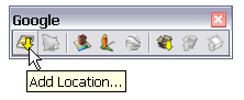
Because that screenshot was made of SU version 6 and you have 8. Use the "Add location" button (and you do not need GE for it either any more)
[attachment=0:a0ojlzo7]<!-- ia0 -->add-location.png<!-- ia0 -->[/attachment:a0ojlzo7]
Maybe if you will show me the trick how to change imaginary source in that "Add loctation" window. But for me it is unusable now, because, and I repeat it again, the source from Google Maps is blured and low quality. So that is the reason why I don't use Google Maps for making screenshots. But I could install SU version 6 because that should solve my problem. I wonder, why developers of SU degraded the SU8 with removing this feature...

-
They didn't degrade SketchUp, they changed the source for the view and terrain data to Maps instead of Earth because Maps has better terrain data. Just because the area you're interested in is not very high resolution doesn't mean they've degrade SketchUp. Using Google Maps also yields color images whereas the old GE imports were only in black and white. With V8 and Maps you can more easily control the size and shape of the area you import and you can get additional locations into the same SketchUp file.
-
I see importing from GE will never work for me. Then it's time for making screenshots...
But I must think up how to solve the Mash. I must make new mash and project topographic map to create new one.
-
Rumcajs, remember that I explained to you how to grab a mesh with the colour imagery projected on it here?
http://forums.sketchucation.com/viewtopic.php?p=425750#p425750 -
What do you mean by "Google" here? Do you want to upload your model to Google Earth?
-
Maybe in future. It is just theoretic. I would like to do it in the way, that I could possibly upload it later.
-
@gaieus said:
Rumcajs, remember that I explained to you how to grab a mesh with the colour imagery projected on it here?
http://forums.sketchucation.com/viewtopic.php?p=425750#p425750Sure, but the problem is that I must to remake the mash. I am not sure - will Google Earth let me create new mash into my model? Because I need make the mash lower - moat is bellow GE mesh level. Only good thing on importing Google mash is that I can find the water surface with it... And then I need to make my own mash. It is above 10-15 meters of elevation or so.
-
All right. So the case is that you can add a (small) "terrain skirt" (as they call it) in the positive direction but you cannot go below the existing GE terrain. So a most cannot be modelled below the existing GE terrain.
-
Ah, then only solution would be to make the model higher, then it should be. Otherwise I could not make the moat there.
-
Yes, that could be the only solution but if this terrain skirt is too extensive, they may reject the model.
-
I think the model will be extensive and will not suite GE criterions... As I understand street view project, they want the buildings to be as simple as possible. But in my project I try to do it as nice as possible. Hence my model will cost a lot of space (on disk).
Hello! It looks like you're interested in this conversation, but you don't have an account yet.
Getting fed up of having to scroll through the same posts each visit? When you register for an account, you'll always come back to exactly where you were before, and choose to be notified of new replies (either via email, or push notification). You'll also be able to save bookmarks and upvote posts to show your appreciation to other community members.
With your input, this post could be even better 💗
Register Login


Advertisement