Digital terrain model from Google Earth
-
Hello to all Members,
I’m a new member in this community and I’m surprised about this many talented people here.May i introduce myself. I’m a retired “stoneaged” mechanical engineer. My special interest is in the reconstruction of historical buildings and all other things which can be constructed with Sketchup.
I came in contact with Sketchup about two years ago. I was immediately enthusiastic with this software. Most of the Sketchup techniques i have learned by online video tutorials.Some of my models you can see here:
http://www.sketchucation.com/forums/scf/viewtopic.php?f=81&t=18835Sorry if my English is not so perfect.
Greetings from Frankfurt/Germany
Karlheinz
Digital terrain model from Google Earth
may be there are users which would like to present models on a terrain that corresponds to the real area. Unfortunately, DEMs are to get in Germany only for a lot of money. I have found an interesting Tutorial at the internet. This tutorial shows a technic how to create height contour lines from the pictures in Google earth. These produced contour lines can be used for modeling a terrain into Sketchup. May be it is interesting for some of you.The link: http://www.alejandrobarzi.com/root/br/Home


-
Hi Karlheinz and welcome to the forum!
Nice find and thanks for that. There was a topic about procedural terrains here if you are interested. Many,similarly interesting ideas:
http://www.sketchucation.com/forums/scf/viewtopic.php?p=65055#p65055I had a look at your gallery post but I'd like to comment it there.

-
That looks very interesting! I work in an architectural office and often have to do terrain for the site, but often lacks enough terrain info.
-
Hi thomthom,
i have a question about terrain views imported from GE. Are the geographical data (coordinates, heights) imported also with the imported view? I'm not shure on which base sketchup calculates the heights of the imported Terrain when "Toggle Terrain" is on.
The disadvantage of the method with the contour lines is that all geographical data are lost.
Do you have an idea.
Karlheinz


-
Sorry mate. I haven't used Google Earth with SU that much. Mainly because Google's data from Norway's been rather poor...

-
When you import a GE snapshot into SU,it will also "georeference" your model relative to the World co-ordinates (you can check this under > Window > Model info > Location).
As for the z-height, unfortunately,it will always be relative to the GE surface only so you can never extract that data from the SU model (as far as I know) although in GE you can find this info if you put a placemark to somewhere.
On top of all, while GE has a spherical co-ordinate system, SU uses a rectangular/orthogonal one which will be distorted more and more you are going away from the origin. So practically it's not a "mapping" program (you can use Arc GIS and its SU plugin to do that).
-
Hi Gaius,
thanks for your technical explanation. Unfortunately, I am not an expert in the area of GIS. Most of the knowledge about GIS I have acquired on the Internet. Somtimes i use Global Mapper. I tried to use ArcGis but it seemed to me as a non-specialist to difficult.
often I have downloaded SRMT terrains from CGIAR-CSI GeoPortal but the resolution especially for German regions is very low. The Problem is that SRMTs and other map materials with higher resolution one can get only from the german land survey offices against much money, so i saw an alternative only in the GE-Terrains. But The GE Terrains are sufficient for my purposes.
A new question now for me is, how to get a realistic street on the terrain. I have already investigated in the forum and Internet. This Question seems to be interesting for many user but till now nobody has found a solution. I will continue to work on.
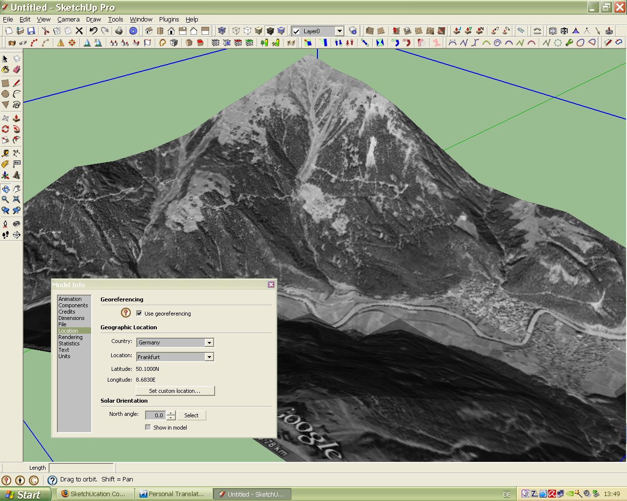
But your note (you can check this under > Window > Model info > Location). I tried this immediately by importing several terrains but in the model info there is only the location which was predefined by me. Have I made any mistake? See picture below.
Greetings
Karlheinz
-
@charly2008 said:
The Problem is that SRMTs and other map materials with higher resolution one can get only from the german land survey offices against much money, so i saw an alternative only in the GE-Terrains. But The GE Terrains are sufficient for my purposes.
The sme here, unfortunately. I'm lucky however because there's a geologist in town whose hobby is to research the ancient ground level in Roman times. This, combined with our data from excavations (we do the survey work ourselves) is sufficient for my reconstructions.
@charly2008 said:
But your note (you can check this under > Window > Model info > Location). I tried this immediately by importing several terrains but in the model info there is only the location which was predefined by me. Have I made any mistake? See picture below.
With SU 7, the pre-set location is NOT overwritten by the newer snapshots. The reason behind this is to be able to take several snapshots within a relatively small area (with bigger areas the spherical/orthogonal differences will make you unable to do it properly).
So your solution would be to open the Location tab > uncheck the pre-set location > take the snapshot and now that will re-geolocate your model to this new location. Be always very careful with this as if you forget to uncheck the original location it will screw up your model. Best is to use a non-geolocated template.
Hello! It looks like you're interested in this conversation, but you don't have an account yet.
Getting fed up of having to scroll through the same posts each visit? When you register for an account, you'll always come back to exactly where you were before, and choose to be notified of new replies (either via email, or push notification). You'll also be able to save bookmarks and upvote posts to show your appreciation to other community members.
With your input, this post could be even better 💗
Register Login


Advertisement