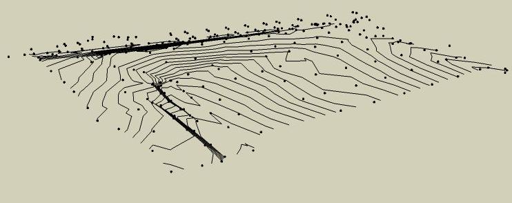
How to make a terrain from contours and points
-
What types of "points" do you have? Is there a way to turn them all into really small line segments? Maybe that will help.
Chris
-
Hi Chris,
My points are "guide points". And yes, I thought about replacing my points by small lines...but my model will be too complex after that...
I join my skp file and a screenshot, in order you can check it if you want.
Thanks.
-
Hi people,
I found a solution, so here it is :
Because the sandbox do not recognize points, we have to use lines, this is a problem. As you said Chris, replace the points by small lines could help but it also will make my model too complex...But there's another problem boring problem with the sandbox : sometimes it ignores some lines, or line vertex because they're too close or...too far ! And here is the solution.
I made long lines from my points in the Z axis, and when I use the sandbox, it picks the top of each line (which is my original point), and it ignores the other extremity of the line, too far below !!
So sometines one defect can be useful to avoid another one !!
Hope that'll be useful for everyone.
See u.
-
Hey, thats really interesting. Thats the kindof trick that might come in handy repeatedly. I'll play with tomorrow,
Chris
-
There is points_cloud_triangulation.rb by Didier in the Ruby Library Depot. it "Creates triangles starting from a construction points selection. Requires delaunay2.rb (optimized delaunay triangulation). Useful to create terrains starting from points cloud data."
You may have some success with it.
-
My guess is that Panga wanted to use the points cloud triangulation - trying to covert lines to points, for example. I've had this problem with survey data, so I was interested in finding a solution.
I thought the problem could possibly be helped by creating lines between points - these would not be true contour lines, but would produce the desired surface. This does require a little care with the lines but works OK. I searched for a ruby file to do this (Join selected points with lines) but came up empty.
His solution gives a better result, I think. It is a bit more work to do manually , but probably simple enough to script. I'm no programmer - but I'll give it a shot.
-
Hi Mozzie and Gaieus,
First, points_cloud_triangulation.rb is only taking points for triangulation, and it ignores completely the path of level lines during the triangulation...too much work after to correct the errors.
If you organise well your file before importing in skecthup, it's not more work using my procedure. I work with autocad files, and all my points are instances of the same block. Sketchup automatically converts each block in a component, so in sketchup I have instances of the same component.
I just have to edit one of them, to draw a line on the z axis, and i'ts done !! Then I explod all the components, select all my contours lines and my new "vertical lines", and use the sandbox. -
Have a look for Simuterra at
-
Thanks for the info, I think I already found int the past that plugin, but I completely forgot it !!

-
Thats great!
I always learn something new here.Thanks Panga.
Advertisement


