Google Earth or "OTHER?"
-
Good day all !!!, as usual I am attempting something WAY!!! over my skill set! I hope someone can give me some direction on what I will need to learn and do, to pull this off. First off this is what I have to work with... SU 2017, ACAD Architectural 2017. My "goal" is to take the entire 3D terrain of island of St. Croix in the US Virgin islands, create a bunch horizontal of slices at different elevations, then just save the slices and create a "stepped" elevation model, although a brute force task, I can "do" that. But what I can't do is figure out how to import reasonably accurate 3D info into Sketchup to do this? I'm still trying to figure out how to get 3D info off of Google earth Pro (still trying, Not smart enough to do this at the moment, Not sure of the accuracy of what I will get?). I even downloaded a 5 GB! file from NOAA which came with so many files and TFW? files, I don't even have a clue on where to start with that way! If anyone has advice on the path I need to follow and things I need to learn, I would GREATLY!!! appreciate it.
Thanks. Matte -
Still playing, At least I have learned... Sketchup 2012 and Blender can't do the job, so still looking. I did see a model someone had for sale for $500, but that's not doable for a "play thing". When I do find a solution, I'll let you all know, hoping to call NOAA to see if the can help to translate their data I downloaded sometime next week.
Matte -
There are several issues that you'll need to sort out. First terrain data import via SketchUp's geo-location feature is not available for SketchUp 2017 anymore. It hasn't been available from Google Earth for a number of years. Second, Google's terms of use prohibit using their terrain and image data as you are using it. (That's why SketchUp doesn't get that stuff from them anymore.)
You might be able to find another source for the terrain information. Perhaps the local governing agency has a GIS department that can supply you with it in a forum you can import into SketchUp. Or maybe it's time to upgrade to the current version of SketchUp so you can use the Geo-Location feature and get the terrain and imagery.
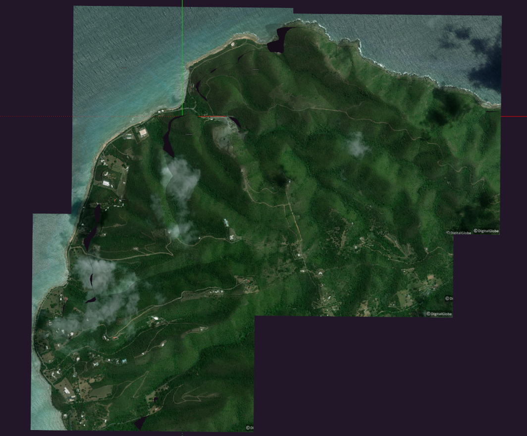
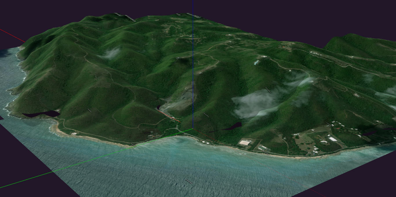
It'll require some patience to get the entire island. This is four sets of data imported.
-
Thanks Dave, I did try 2021 and saw it can do what you are showing. I guess if I make 50 or 60 "tiles" I can stitch them together. I was just thinking that might make a month project into a year project! But if NOAA or the USGS can't help I might give that a try. Thanks again as always, you advise is brilliant!
-
You're quite welcome and good luck. It is a little slow adding in the small sections one at a time using SketchUp's Geo-Location feature. Maybe you could move to a much smaller island.

Good luck. Hopefully one of your options can provide you with suitable data.
-
Thanks Dave ! As soon as I win the lottery a smaller island might be the key!
 But I am here so I'll just have to deal with it. Started a "bad" quality map for now. I spent 10 hours last night after work downloading the 50 or 60 tiles by questimation since there in no tile mode for big models in sketchup 2021. Too bad, that would be a good enough excuse enough to upgrade! That or major Layout improvements! So now, I just have to hand stitch each of the 60 tiles (800 - 900 triangles) together by hand, should only take a few more weeks. Then I can make my stepped terrain from that! Thanks for the motivation to attempt the brute force method. It's not pretty, but it will at least give me something to gauge against as I look for the "right" way to do it.
Thanks again, Matte -
PS... Funny the image you sent, it's in the middle of nowhere... I just went exploring Sunday.... And that's the abandoned building I ended up at!
-
When you win the lottery and buy your own island, let me know. I'll come for a visit.
I guess most users don't need to import nearly 85 square miles of terrain so the focus is on smaller areas. That is going to create a huge file when you get finished. Hopefully you can delete that terrain once you get your contours.
@unknownuser said:
And that's the abandoned building I ended up at!
Did you feel like someone was looking over your shoulder from a great height.

-
Searching under LIDAR, NOAA has very good aerial images from a few years back. But I don't know how to get the LIDAR elevation data out or how to bring the images in at scale. You may need a GIS specialist to do that (locally we can download dwg files of the LIDAR contours). Here's an example of the resolution. I downloaded .jpg files of the whole island. They're pretty big.
Hello! It looks like you're interested in this conversation, but you don't have an account yet.
Getting fed up of having to scroll through the same posts each visit? When you register for an account, you'll always come back to exactly where you were before, and choose to be notified of new replies (either via email, or push notification). You'll also be able to save bookmarks and upvote posts to show your appreciation to other community members.
With your input, this post could be even better 💗
Register Login


Advertisement