GIS SOFTWARE recommendation reqd.
-
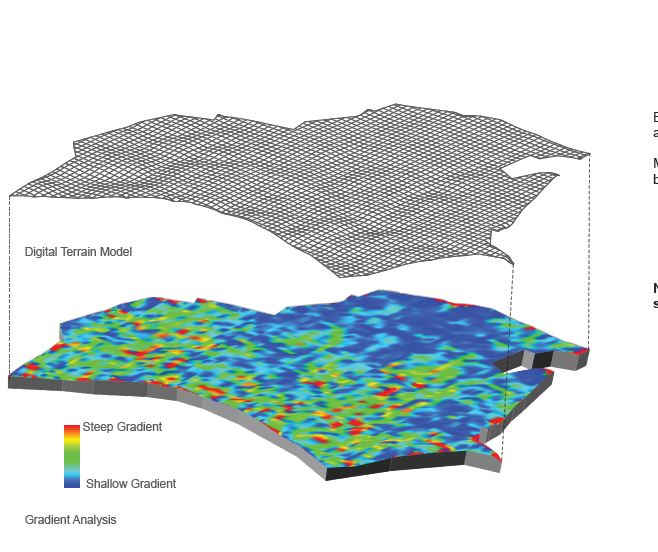
I need to generate slope analysis of a site very quickly using some GIS software. I am a novice when it comes to GIS. Google earth and grabbing a terrain in sketchup is the only thing that I have ever touched upon. These are some samples that I got.
I don't want a heavy duty bulky intimidating software. I just need to do this task. Kindly suggest a suitable solution for me. Moreover, that mesh is a vector linework that was generated.
-
There was a plug-in for Sketchup that did just that - try searching "Color by Slope". I haven't used it recently though. It paints surfaces according to their slopes. There is also a "Color by Height" variant. These might work for you.
-
@cemyapca said:
There was a plug-in for Sketchup that did just that - try searching "Color by Slope". I haven't used it recently though. It paints surfaces according to their slopes. There is also a "Color by Height" variant. These might work for you.
I have tried sketchup but it never works out. Here, http://sketchucation.com/forums/viewtopic.php?f=15%26amp;t=57167
-
Try this and read it in depth (It's Chris' ColorBySlope tool)
http://sketchucation.com/forums/viewtopic.php?f=15%26amp;t=56825%26amp;p=516133%26amp;hilit=+slope+analysis+#p516133vid howto
http://www.sargeantillustration.com/tutorial-slope-analysis-in-sketchup/Subdividing your mesh will help produce a better blur effect but dramatically increase processing time.
You will always get some sort of tiling effect (but turning linework OFF will help a lot) but you can always blur/smudge in photoshop/gimp/fotosketcher
QGIS is the other viable approach but if you know nothing about GIS it's a lot to take on board in an afternoon! QGIS will get you there tho
http://www.qgis.org/en/site/But it's not quick to explain - WELL worth learning tho' for another time.
-
My wife has been working in GIS for years, with ESRI. She recommends qGIS and thinks someone like me (with CAD background) might pick it up OK.
-
Re QGIS - I'm self-taught in GIS and tend to use it for simple things like converting tiff file data (look like a monochrome image file, but each pixel contains for instance height data) into dxfs and so getting a contour file. Currently am working on using it to produce variable-width setbacks for waterway protection - which IS pretty difficult, but like this place there are great communities to ask questions.
-
@pbacot said:
My wife has been working in GIS for years, with ESRI. She recommends qGIS and thinks someone like me (with CAD background) might pick it up OK.
Thanks I will try this with qGIS.

Hello! It looks like you're interested in this conversation, but you don't have an account yet.
Getting fed up of having to scroll through the same posts each visit? When you register for an account, you'll always come back to exactly where you were before, and choose to be notified of new replies (either via email, or push notification). You'll also be able to save bookmarks and upvote posts to show your appreciation to other community members.
With your input, this post could be even better 💗
Register Login


Advertisement