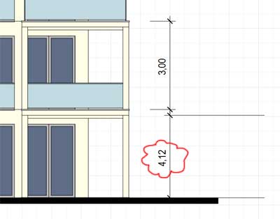
How to dimension elevation?
-
Hi everbody,
I am trying to put some dimensions into an elevationplan. But the dimensioning tool seems to snap somewhere inside the depths of the SU model yielding incorrect results (see image, dimension should be 2.80). This happens almost all the time and is a real pain. (The flipped extension lines problem I posted seperatly).
How can I make LO snap correctly?
Thanks for any help.
Regards
Mikar

-
-
I use elevation tags to show heights on elevations. LO is actually giving you a correct dimension, but it is measuring at an angle. If you don't want to use elevation tags, simply draw a line in LO from the two points you are measuring, lock the LO layer that the model is on, and add a dimension between the two lines you've drawn set to the appropriate scale.
If you are careful with the dimension tool, you can use inference instead of actually pinning a point that may not be aligned with the first point selected. This will result in the correct vertical dimension.
-
Hello Sonder,
thanks for the idea with using helplines and dimensioning those. Works fine but as you said needs some extra thinking regarding paper scale and model scale. I came up with a solution by dimensioning an exploded copy of the SU model on a seperate layer, which flattens the elevation drawing and therefore eliminates any snapping into the depth of the model yielding angled dimensions.
Regards
Mikar -
Mikar - this is why I use standardized templates for each drawing type. The scales are preset. You should have your model set to scale obviously and then your dimension tool set to that same scale.
Exploding the SU model for me would take up too much time due to the file size.
Advertisement


