Recurrrence: First Geolocation works - Add imagery fails
-
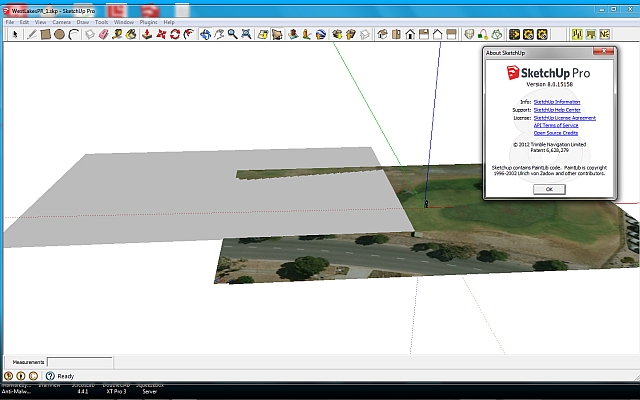
This problem first occurred about a year ago, IIRC. The first geolocation image and terrain imports fine, but the subsequent "Add imagery" fails to bring in the image.
I'll post to Trimble, as well. -
A solution to this may be obvious to someone who does this on a regular basis, but could you elaborate on exactly what is happening? Why is that grey plane skewed wrt the ground image?
-
Thanks for your response.
I use Geolocation regularly; it's an integral part of my workflow. This is a very recent development, (last week or so). It may be location specific.I have found a workaround in this case, which is to reduce the zoom (zoom out) a step or two.
EDIT - the odd intersection is not something I did - the blank plane seems to be at a small angle, or an artifact, as it changes with rotation - disappearing or getting worse.
-
It's the old Style Menu issue (revisited after upgrade). Easily, if not obviously, fixed and for the record;
Window -> Styles -> Edit [tab]-> Match Photo sliders (may need to scroll down) -> Foreground Photo (tick box on).
For some reason, I'm not wired to see Geolocations terrain display issues as Style problems!
Hello! It looks like you're interested in this conversation, but you don't have an account yet.
Getting fed up of having to scroll through the same posts each visit? When you register for an account, you'll always come back to exactly where you were before, and choose to be notified of new replies (either via email, or push notification). You'll also be able to save bookmarks and upvote posts to show your appreciation to other community members.
With your input, this post could be even better 💗
Register Login


Advertisement