Dimensions
-
I want to measure height of tower, but am not succesfull to measure its whole height. There is not center point in the base (and I dont know how to find it, not so simple). So when I start to draw dimension line from one corner of the base, I finish not at the top of the roof, but in the point where last floor begins. Why? Because if I would go on top of the roof - which is in middle, so the line will not be streight but would go to x axis. So I need to a way how to draw the "side line", that will point to top of the roof.
-
Are you in LayOut or SketchUp. Can you post the model?
-
I am in sketchup. Wait I will send the model.
-
Here it is.
http://www.4shared.com/file/mlzdxAnl/CHATEAU_scaled_preparing.htmlYou will see I have drawn some dimensions but they do not include the top of roof.
Yet let me know if can I change measures during changing entity size, scale or angle.
-
Can you send through PM or attach to the post?
-
No, it is big file.
-
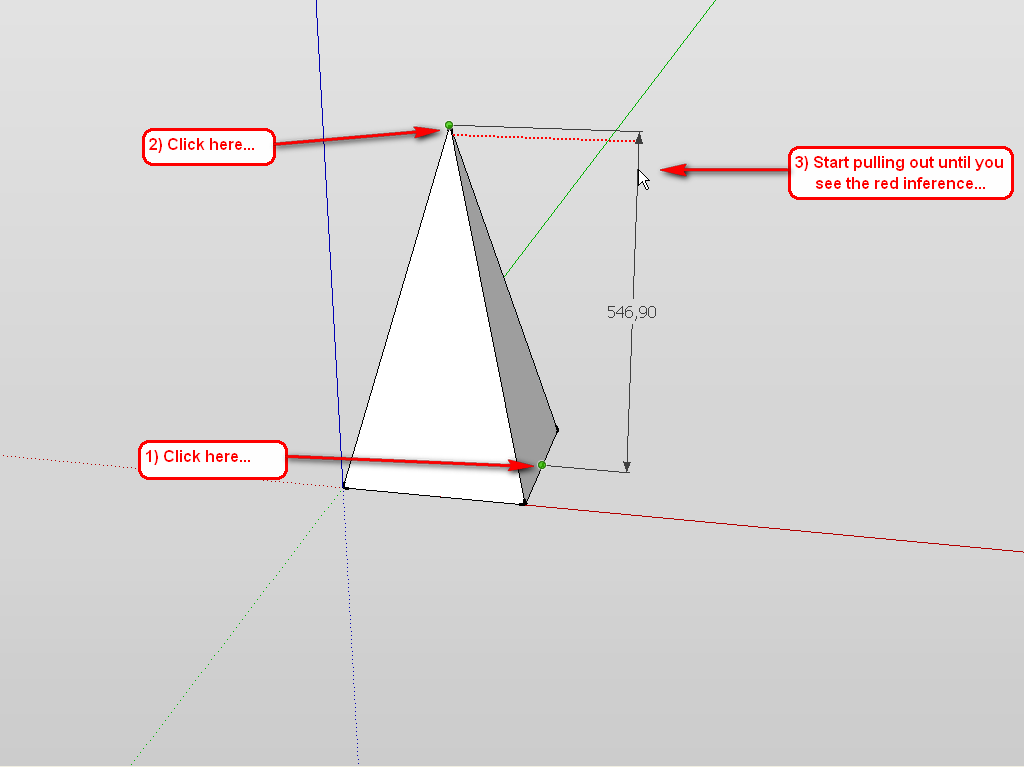
I'm not sure where you have the problem with dims but you can check the following steps:
- Start at the bottom (1st click - midpoint or endpoint of a face)
- Go to the top of the tower (2nd click - midpoint or endpoint of a face)
- Drag the dimension outside the model and look for the 'dotted' guidelines (PINK is perpendicular to two dim anchor points when you do your dims and doesn't follow X,Y,Z...
...but you are looking for RED, GREENor BLUE
In your model the PINK guideline would appear first (because doesn't follow X,Y,Z)...
move your mouse slightly downwards to see the RED or GREEN upwards to see BLUE
4. Then 3rd click wherever you want- REDdotted guidelinewould follow X axis
- GREEN dotted guidelinewould follow Y axis
- BLUE dotted guidelinewould follow Z axis
-
Like "beginner" said: you can always force inferencing in SketchUp...
-
Gaieus,
Very good illustration of my long, long post. Nice one...
-
Thanks guys. Beginner already explained it to me and I had understand it on second time. It just confused me when he said that I should not click purple points (I think he said it but cannot to check it now)...
Somebody could make animation for guide in next version of sketchUp
-
If two guidelines intersect itself in different level (it is unwanted effect coz I want them to be same level, but in for case...) when I measure by Tape from one intersection point to another... I have parallel view on. How can I prevent that the starting or ending point would be in incorrect level? To be exact, I measure distance on a shape with a texture. So I measure if the texture is correctly sized. But if the points would be not on same level, so it will measure wrong. How to prevend it in the case that I have the guides like so?
-
Best would be (when you are at this stage) to bring everything to level (as Dave suggested before). In case you need to measure distances of things at different levels however, you can always "force" inferencing in a variety of ways.
If whatever you want to measure is along/on a certain axis, pressing the up/down arrow will force it on the blue, right arrow on the red and left arrow on the green axis (but "beginner" has already mentioned this to you above).
Further, if you are out of an axis but have an edge/guide to measure along, right after you get the "On line" inference, press (and hold) the Shift key to keep it on that edge / guide (or in fact, parallel/perpendicular inference or on face etc.) Now you can bravely snap to your other guide or any point and keep your measurement on the original entity.
I think you are overcomplicating this thing though. From various topics of yours, I suspect that your problem is that you want to adjust the aerial imagery right below the castle you are modelling, right? I would definitely approach the whole thing differently.
If you got the imagery from Google Earth (by geolocating your model), you should already be exactly over that imagery with your castle. In this case, you simply paint the roofs with the Google imagery sampled.
If not Google, try to draw a big face below your castle. Considerably below so that the geometry does not touch. Now select all the bottom edges of your castle and make them a group. Then use the Drape tool of the sandbox tools to project these edges onto this face below the castle.
Once you are done, hide the castle itself and now you have a very handy "plan" of your castle on which you can easily position your image. Use "free pion mode" to freely adjust the image (stretch snapping to the outline edges). Although this is easiest with rectangular faces, it can also be done on some irregular shapes as well (although sometimes with some inaccuracy only, if the image is also distorted).
There are some very good instructions on how to set up precise measurements here
 (although admittedly I cannot understand too much of what's been said there)
[flash=640,480:3ildt01t]http://www.youtube.com/v/c0ScBNCT2rs[/flash:3ildt01t]
And when we are at it, Jičín seems to be quite nicely modelled in Google Earth. At least the old town...
-
Thanks. In the meantime of my reading, here is your translation for the story.
Rumcajs for cuckoo get at prison nearly. The banbit Rumcajs has counted how long he will live... When the cuckoo stopeed cuckoo, he wanted to find he to make he more cuckoo...
Then some (magician or surveyor) tries to kill the cuckoo and Rumcajs stops him to kill her.
Then surveyor tries to do some measurements on the rock and owners of the rock (Manka and Rumcajs) does not like it.
The woman asks the man what does he do there and why did he says anything. The surveyor says that the rock is of king of Praque and that the king wants to build a castle on that rock. Rumcajs said, it is not possible coz in Jicin masonries are free of work ("fajrum/fairum") at Saturday.
Then the magician had prisoned Rumcajs. Manka ask how to open the lock. The story is finished with the free of Rumcajs and cuckoo had counted how long Rumcais will stay alive... -
All right, thanks. Great tale (I remember from my child-hood
)Now back to your problem: does any of my suggestions work?
-
-
What do you think to bring all to one level. Do you mean to create ground plane? Or do you mean to move rules to same level, which sound complicated but I tried yestearday. You will not believe but I did it more then 5 hours! I am gonna learn how to use scenes, coz views bad always theribly slow me down!
-
Yes I used the arrows but in different cases. I try it especially with move tool. So do you say, that when I take the measurement tool (for resize object in this case), I must first
A) check the plus sign is off (ctrl switch)
B) the left or right arrow is pressed to force the horizontal axis
Then I can start measuring/scaling. -
I use the inference lock always when I work with inference
I don't know if the model is from GE. I measured the image and it does not fit. The model is too bad in detail and in height, so I am going to crate new one. I resized the GE photo yesterday, and I will use 2 more plans for it. So I gonna create 4 layers for those.
"Google imagery sampled" - what and how? Some tool by Google?
"If not Google, try to draw a big face below your castle. Considerably below so that the geometry does not touch. Now select all the bottom edges of your castle and make them a group. "
I did group of the plane, which is ground plan... but this was just for check.
My big pitty here was the fact that rules were hidden with section plane, so I needed to create new copy of the ground plane/basement of castle (needless?)...DRAPE TOOL - ok I will check it
I am not from Switherland to do the mesurement and event don't have mesuring aparature. I counted height of buildings from shadows lenght. The model (especially towers) was at least 2x heigher then it should be...
Hiding - I do it through layers - I wanna larn how to hide object in active layer... link?
I gonna to build every one building and group it, because this way it will be much more usable then in the state as the model is now (ungrouped).
I gonna try the scenes now and learn if you send link for hiding object in active layer.
-
-
So it's not your model? But it's apparently an existing building, isn't it? Then to get the proper layout you have two choices: get the Google imagery (via geolocation) or get some real measurements of the model and start building from there (and most probably, a new model from scratch would be best). Where is it anyway?
IMO you started with the whole learning curve with a rather complex model which does not allow easy to learn, small steps but faces you with some or the hardest scenarios.
@rumcajs said:
I resized the GE photo
That's not good - at least in case you got the image from the get location function. It comes in with a perfect 1:1 ratio so that's how you should start with.
-
@gaieus said:
So it's not your model? But it's apparently an existing building, isn't it?
It is imported from 3D gallery (warehouse). Not mine. It is building in Switzerland.
@gaieus said:
@rumcajs said:
I resized the GE photo
That's not good - at least in case you got the image from the get location function. It comes in with a perfect 1:1 ratio so that's how you should start with.
I have the image from GE, but I had to resize it for meters => it is enlarged. 110m is length of the castle but the image is much more less size.
What do you mean by geolocation?
-
@rumcajs said:
I have the image from GE, but I had to resize it for meters => it is enlarged. 110m is length of the castle but the image is much more less size.
You can scale your building to a proper size with the Tape measure tool. An entire model: http://support.google.com/sketchup/bin/answer.py?hl=en&answer=95006 or just an entity (group, component): http://support.google.com/sketchup/bin/answer.py?hl=en&answer=116447
@rumcajs said:
What do you mean by geolocation?
This: http://support.google.com/sketchup/bin/answer.py?hl=en&answer=95069
This way you can get the exact location and exact size of the building into your file. I suppose however that the original download also had this location already. -
That's what I did, I resized it with tape of sure. Not the raster itself...
This is what I am doing now.
http://i48.tinypic.com/34pfc69.png
http://i45.tinypic.com/2a5i3qg.png -
Yeah, but the original image is in grayscale and does not
http://i50.tinypic.com/347k6r7.png
extra quality
http://i46.tinypic.com/zyf29c.pngIts very blurred and low detail.
This is photo from GE, and much more better quality:

(Measuring of shadow's length)
Hello! It looks like you're interested in this conversation, but you don't have an account yet.
Getting fed up of having to scroll through the same posts each visit? When you register for an account, you'll always come back to exactly where you were before, and choose to be notified of new replies (either via email, or push notification). You'll also be able to save bookmarks and upvote posts to show your appreciation to other community members.
With your input, this post could be even better 💗
Register Login


Advertisement