Terrain Modeling Question
-
Haha. I wouldn't even think of a 100 metre run with my almost 30 years of smoking habit!

Anyway, I have a cataract in my right eye (used to have one in the left as well but that was operated some 2.5 years ago already). Now it's about high time for the right eye as well.

-
jakob and csaba,
i still prefer the intersect way over the drape tool as it is not always reliable. and jakob, do not you get notifications by email about the topics you subscribe to?
-
True that the drape tool in not always reliable although often it is not because the imported dxf linework does not close properly (i.e. you couldn't create a simple face with it either).
Also, as I experienced, the drape tool ha been greatly enhanced in SU 7 - and it is also faster than before.
-
Hi Gaieus,
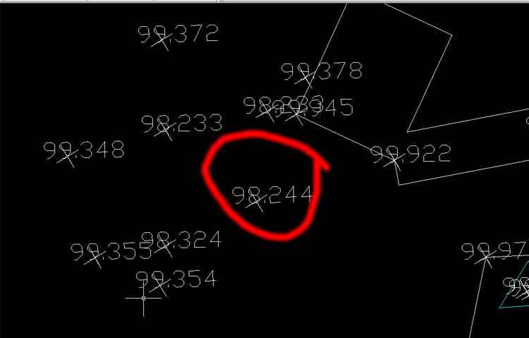
I only just joined the community and have been reading your thread about the scripts etc to convert spot points from autocad accross to sketchup - i'm not a coder but i have worked with computers for 20 years so i'm hoping i'm not stupid but i've tried all the links and have not been able to get it to work - could you point me in the right direction!! - i've got about 2-300 points in an autocad file from an architect each point has a cross and a 6digit decimal (ie 100.040 ) .any advice much appreciated!
cheers
tim davies
-
Hi Tim and welcome!
Are those "crosses" components when imported to SU? The best would be if they were instances of the same component (as I remember a topic with such a case).
What do the digits stand for? Elevation maybe?
-
Hi Gaieus, Thank you for your time in getting back to me.
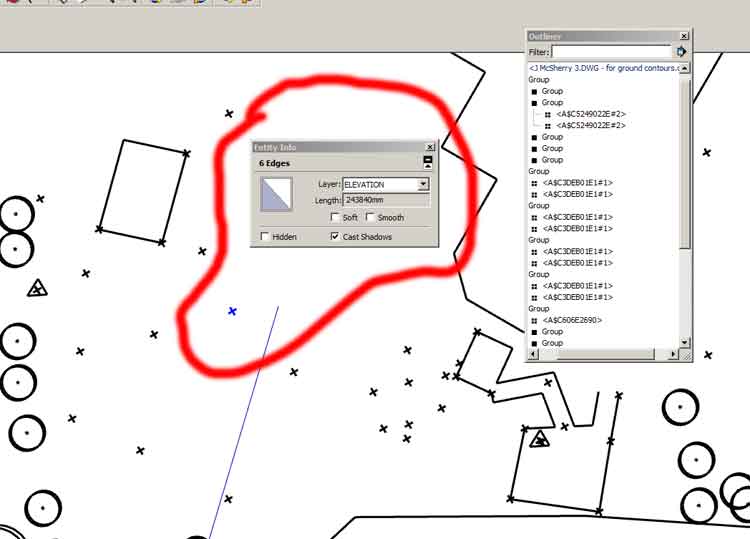
i've attached a screenshot showing the number data with the cross (x) as it appears in Autocad and then in su7 how the points come in without the numbers and just the x which have 6 edges and also a length!thanks again for your time .

'Rome wasn't built in a day, but they didn't have sketchup!'

-
SU does not import CAD Text objects, but if those "crosses" are at the right elevations, you can use the Sandbox from Contours tool to fit a terrain surface onto them. It may not be the most beautiful one, but it might work.
Anssi
-
thanks guys for your advice - i just checked and the elevation data isn't there - all the crosses have the same value in entity info and are the same plane! i'm going to try and fudge it!
-
Tim, it looks like the survey you have is in 2D only. Go back to the architect who could ask the surveyor if he has done the survey with 3d points. I've had a few situations where the 3D information is collected in the survey but you have to request it in 3D format otherwise it is sent out in 2d only.
Failing that, the numbers you have are spot heights which can be converted to 3D. See this thread: http://www.sketchucation.com/forums/scf/viewtopic.php?f=15&t=14409&st=0&sk=t&sd=a&hilit=cloud
I couldn't get it to work at first but email the developer who is very helpful if you have a problem.
Kenny
-
To convert in AutoCad text survey data to 3D geometry that can be sandboxed, you can try the attached lisp file I once made that might be similar to the one mentioned by TIG in the thread Kenny pointed to.
It is very simple: it takes a text entity, reads it, converts the data into a number, multiplies it with a factor you supply (in case of survey data in meters in a file in millimeters, common in my case) and draws a short line with the z coordinate set to the calculated number. Not very accurate but sometimes usable. The line xy location is derived from the text insertion point.
Usage: Unzip to a location where ACAD can find it. Type (load "txt23d") to the ACAD command line and press Enter. Type the command txt23d and Enter. Select the text objects and press Enter.
The lisp has not much error processing so save your DWG file before using it. If the texts use another decimal separator than a point, you should replace them with points before using.
Anssi
-
Hey annsi and kenny - thanks for that i'm going to give it a shot - will keep you posted! -
-
Tim,
Hope that converted file is of some use to you.
Cheers,
Wayne Ashey
mr_ashley@little-something.com
http://www.little-something.com
Advertisement


