Script to make edges into a curve: needed
-
regis,
there are thousands of segments! it becomes a mammoth manual job. this is not what CAD was supposed to be.
besides, the idea is to turn each contour line into a segment before i make the survey lines into a terrain. so, there would be no segments connected to my curves.
-
@edson said:
besides, the idea is to turn each contour line into a segment before i make the survey lines into a terrain. so, there would be no segments connected to my curves.
I don't understand exactely what you mean
An ilustrated example perhaps
regards
-
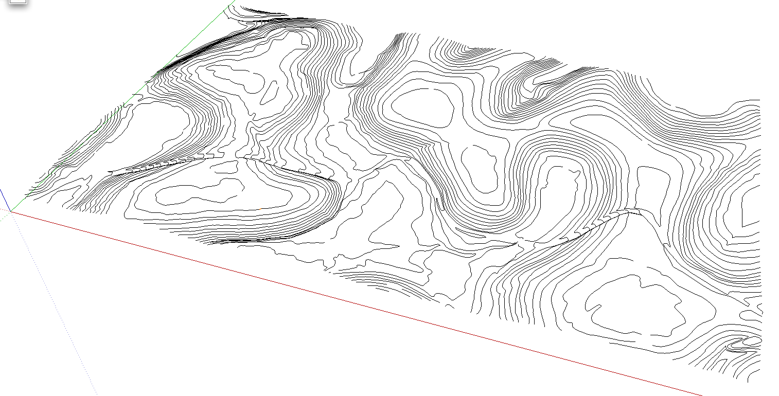
the image below shows what you get after importing a survey map: a bunch of contour lines made up of thousands of little segments.
what i wanted was to turn them into polylines (each contour line being a polyline). weld is supposed to do that but it has not worked for me.
-
Edson,
Let them be individual edges or polylines - they will equally (badly) affect performance in SU. Certainly it's easier to work with single entities (i.e. a polyline instead of hundreds of little line entities).
It's generally the question whether you need such a detailed mesh or not. If not, you may consider using less detailed contour maps (but of course, you work with what you get) or use the "simplify contours" ruby script.
-
Wow
I would like to try.
How do you got this survey map? Is it free?Have you tried to vectorize this map in illustrator perhaps and export to sketchup as dwg file ?
regards
edit. I know what's a survey map now. -
@regis said:
Wow
I would like to try.
How do you got this survey map? Is it free?Have you tried to vectorize this map in illustrator perhaps and export to sketchup as dwg file ?
regis,
the survey map was already provided to me as a dwg file. it was part of the info material for a competition i took part in recently. in this case it was free to all participants.
the other way i receive survey maps is when i am working for a client and he(she) hires a surveyor to do it as a previous necessary step before i can start working on the design of some building. in this case it is paid.
-
@gaieus said:
If not, you may consider using less detailed contour maps (but of course, you work with what you get) or use the "simplify contours" ruby script.
csaba,
do you know exactly what the simplify angle dialog box means? it asks me to enter an angle and i never quite know what to put there. depending on the angle some contours disappear.
-
To tell the truth, Edson, I have never used that ruby in my life. But assuming (from the description) that it will simplyfy the whole mesh, the angle you need to enter is an angle on the z axis (elevation / or you could imagine a cross section of the whole topo) and where the contour lines are very dense, msome of them are ommitted (deleted).
OR (and it seems to be more logical) maybe when there is just a very slight difference between two faces in angle, it deletes the contour line in between because it would not make much difference anyway - the slope won't apparently change on a design work. Surely for final planning, the more detailed the topo is, the more precise the architect's work can be.
-
Edson,
I don't understand why weld doesn't work on your contours.
I'll be happy to make tests with survey map so if you have one to share you can upload on the forum or send me by PM, it will be much appreciated.
regards
-
Edison, I think I may a have a workaround for you.
I am certainly not an expert at dealing with contours, but through recent experimentation and the availabilty of newer scripts this could be what you need.
You'll will need to check the accuracy of the "re-segmented" contours, however, to see if they are within the tolerances/lever of accuracy you want.
See the attached .skp for a mini-tutorial. You will need the Weld.rbby Rick Wilson and the BezierSpline script setby Fred06. If you plan to create a terrain from the contours, then I would suggest TIG's Hidden2Layer.rb (version 1.2) script and use it as mentioned here: http://www.sketchucation.com/forums/scf/viewtopic.php?f=57&t=8726 .
In summary, the procedure is this:
A. Import the contours.
B. Triple click on a contour of segments and WELD.
C. Then right click on it and choose the the BZ context option of PolyLine Divider. Do note that for some reason (I think it has to do with the number of segments), the BZ context options may not be available; in that situation then bisect the weld segments into smaller lengths (see the mini-tutorial, Step 2).
D. After completing Step 3, then you may want to weld the "segment-reduced" contour path back together into one continuous polyline. Mini-Tutorial for BZ method of segment reduction
UPDATE: If Weld.rb does not work on all segments of a contour, try a selecting a smaller set of segments. OR, try selecting a few contour elevations (use one of SU's side views to do this), copy and paste them into a new file (or create a component out of them and then do a context menu Save As to create separate .skp), then try to weld, etc., then repeat the process for another set of contours; finally paste these back into one file. Otherwise, have the segments simplified by the surveyor in AutoCad first, or have them subdivide the one DWG file into 4 or more subfiles.
Hello! It looks like you're interested in this conversation, but you don't have an account yet.
Getting fed up of having to scroll through the same posts each visit? When you register for an account, you'll always come back to exactly where you were before, and choose to be notified of new replies (either via email, or push notification). You'll also be able to save bookmarks and upvote posts to show your appreciation to other community members.
With your input, this post could be even better 💗
Register Login


Advertisement