Sloping ground and working drawings
-
I am modeling a house for the purpose of doing working drawings. The house, the garage and the site are on the same level, which seemed to be fine until I came to model the outside structures (an elevated wooden deck, a spiral staircase, a gum pole gazebo and a fish pond) that are on a lower level as the ground is sloping.
What is the best way to go from here? If I model them lower than the floor level of the house then the house will be in the air as it were?
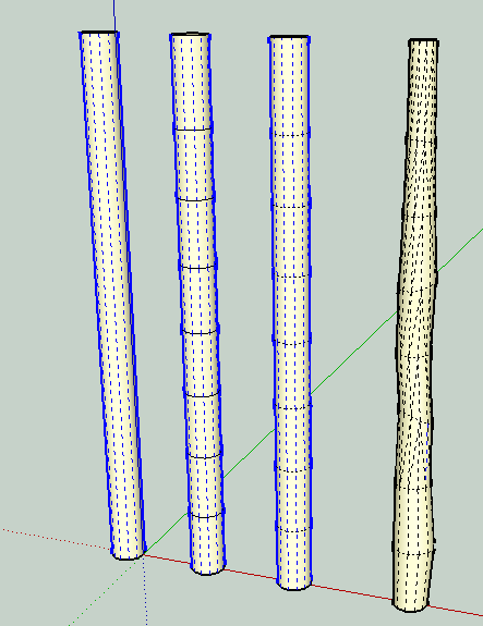
Is there something special that I can use for the rough gum poles or must I just use the circle tool?
Thank you.
-
The house will be on the ground that you also model.
Here's one idea for the poles (I am assuming a gum pole is pole made from the trunk of a gum tree with minimal milling?). You can duplicate the circle up a cylinder. Don't use too many segments to start--makes it look more irregular. Soften the rings and then use the scale move and rotate tools on each to give the pole some shape. You would use hidden geometry on to perform the shaping,if you do it after smoothing. You can probably make one or two components and rotate the copies so they don't look like the same trunk

-
@smarque said:
I am modeling a house for the purpose of doing working drawings. The house, the garage and the site are on the same level, which seemed to be fine until I came to model the outside structures (an elevated wooden deck, a spiral staircase, a gum pole gazebo and a fish pond) that are on a lower level as the ground is sloping.
What is the best way to go from here? If I model them lower than the floor level of the house then the house will be in the air as it were?
Is there something special that I can use for the rough gum poles or must I just use the circle tool?
Thank you.
Little bit confusing in words (for me anyway) are you able to attach some sort of illustration or cross section?
-
If you are looking to create terrain to model on, you can turn on your sandbox plugin, draw some quick topo lines (even better if you can get topo lines from an existing map/gis website) and then simply hit the 'from topo lines' tool in the sandbox tool kit and whalla you've got your site topography to model your deck, patio, & landscaping on. Sometimes I prefer to model the landscaping (paths, walls, etc.) in a plan view, then elevate the lines directly over the sandbox topography and use the drape tool to place the lines I need on the generated slope. Lots of tutorials I'm sure on how to use the sandbox tools.
Advertisement


