sketchucation logo sketchucation
    • Login
    ℹ️ Licensed Extensions | FredoBatch, ElevationProfile, FredoSketch, LayOps, MatSim and Pic2Shape will require license from Sept 1st More Info

    Terrain elevation calculator

    Scheduled Pinned Locked Moved Plugins
    10 Posts 4 Posters 855 Views 4 Watching
    Loading More Posts
    • Oldest to Newest
    • Newest to Oldest
    • Most Votes
    Reply
    • Reply as topic
    Log in to reply
    This topic has been deleted. Only users with topic management privileges can see it.
    • T Offline
      tspco
      last edited by

      I recently have a need for a quick way to indicate the highest, and lowest points, using the origin as a fixed reference. I currently use Chris Fullmer's on screen display to do this, but it is difficult to judge the terrain to find the highest, and lowest points, while looking at it, especially when the difference is less than 20 feet.
      Any suggestions?

      SU make 2017, /Twilight Render Hobby
      Windows 10,64 bit,16GB ram, quad core Athlon 3.6 gHz proc. Anything else you want to know, ask me.

      1 Reply Last reply Reply Quote 0
      • sdmitchS Offline
        sdmitch
        last edited by

        To find the location of the highest and lowest points, you would need to look at every edge making up the terrain mesh. The only way to do this efficiently would be a plugin such as

        
        def label_high_low
        mod = Sketchup.active_model
        ent = mod.active_entities
        sel = mod.selection
        hi_pt=nil;lo_pt=nil;hi=-1e9;lo=1e9
        hi_vec=[0,0,2400];lo_vec=[0,0,-2400]
        grp=sel.first;#select the GE 3D terrain 
        grp.entities.each{|e|
          if e.class==Sketchup;;Edge
            (hi=e.start.position.z;hi_pt=e.start) if e.start.position.z>hi
            (lo=e.start.position.z;lo_pt=e.end) if e.start.position.z<lo
            (hi=e.end.position.z;hi_pt=e.end) if e.end.position.z>hi
            (lo=e.end.position.z;lo_pt=e.end) if e.end.position.z<lo
          end
        }
        ent.add_text(hi.to_s,hi_pt.position,hi_vec)#label the high point
        ent.add_text(lo.to_s,lo_pt.position,lo_vec)#label the low point
        end


        Nothing is worthless, it can always be used as a bad example.

        http://sdmitch.blogspot.com/

        1 Reply Last reply Reply Quote 0
        • T Offline
          tspco
          last edited by

          So it is do-able, how hard would it be to make it work?
          This is my first look inside a "plugin" but I wouldn't have a clue what everything means.

          SU make 2017, /Twilight Render Hobby
          Windows 10,64 bit,16GB ram, quad core Athlon 3.6 gHz proc. Anything else you want to know, ask me.

          1 Reply Last reply Reply Quote 0
          • sdmitchS Offline
            sdmitch
            last edited by

            Not hard at all. I will make it into a normal plugin that you can access from the Plugins Menu.

            Check for PM.

            Nothing is worthless, it can always be used as a bad example.

            http://sdmitch.blogspot.com/

            1 Reply Last reply Reply Quote 0
            • X Offline
              xrok1
              last edited by

              why not just make a plane at 0 copy it up with the spacing you require (say 10') then do an intersection and hide the planes. You will then see rings like a make shift topo map. You can put the edges on a seperate layer and hide/show as you please.
              site.jpg
              SITEplanoverview.jpg

              “There are three classes of people: those who see. Those who see when they are shown. Those who do not see.”

              http://www.Twilightrender.com try it!

              1 Reply Last reply Reply Quote 0
              • T Offline
                tspco
                last edited by

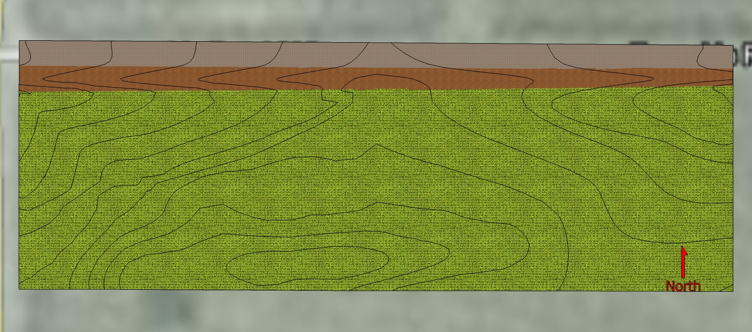
                With a plugin that was made for this purpose, and a projected texture this what I get, good enough for me for now.


                jeffery1a.jpg

                SU make 2017, /Twilight Render Hobby
                Windows 10,64 bit,16GB ram, quad core Athlon 3.6 gHz proc. Anything else you want to know, ask me.

                1 Reply Last reply Reply Quote 0
                • T Offline
                  tspco
                  last edited by

                  Here is another view, I forgot to erase some items, sorry.


                  jeffery1.jpg

                  SU make 2017, /Twilight Render Hobby
                  Windows 10,64 bit,16GB ram, quad core Athlon 3.6 gHz proc. Anything else you want to know, ask me.

                  1 Reply Last reply Reply Quote 0
                  • X Offline
                    xrok1
                    last edited by

                    I guess i did miss the point. 😳
                    Didn't Chris make a plugin alone these lines? (min,max)

                    “There are three classes of people: those who see. Those who see when they are shown. Those who do not see.”

                    http://www.Twilightrender.com try it!

                    1 Reply Last reply Reply Quote 0
                    • T Offline
                      tspco
                      last edited by

                      Don't know about Chris's version, sdmitch did one the other day, works as I needed it to.

                      SU make 2017, /Twilight Render Hobby
                      Windows 10,64 bit,16GB ram, quad core Athlon 3.6 gHz proc. Anything else you want to know, ask me.

                      1 Reply Last reply Reply Quote 0
                      • A Offline
                        aile009
                        last edited by

                        @sdmitch said:

                        To find the location of the highest and lowest points, you would need to look at every edge making up the terrain mesh. The only way to do this efficiently would be a plugin such as

                        
                        > def label_high_low
                        > mod = Sketchup.active_model
                        > ent = mod.active_entities
                        > sel = mod.selection
                        > hi_pt=nil;lo_pt=nil;hi=-1e9;lo=1e9
                        > hi_vec=[0,0,2400];lo_vec=[0,0,-2400]
                        > grp=sel.first;#select the GE 3D terrain 
                        > grp.entities.each{|e|
                        >   if e.class==Sketchup;;Edge
                        >     (hi=e.start.position.z;hi_pt=e.start) if e.start.position.z>hi
                        >     (lo=e.start.position.z;lo_pt=e.end) if e.start.position.z<lo
                        >     (hi=e.end.position.z;hi_pt=e.end) if e.end.position.z>hi
                        >     (lo=e.end.position.z;lo_pt=e.end) if e.end.position.z<lo
                        >   end
                        > }
                        > ent.add_text(hi.to_s,hi_pt.position,hi_vec)#label the high point
                        > ent.add_text(lo.to_s,lo_pt.position,lo_vec)#label the low point
                        > end
                        > 
                        

                        This episode code is the right thing i'm looking for. It provides an addititonal option
                        for Mesh2Heightmap. because the mesh2heightmap generate a greate heightmap but not provide
                        the minimum and maximum elevation values without which i can not use this map to generate
                        an accurate terrain.

                        1 Reply Last reply Reply Quote 0
                        • 1 / 1
                        • First post
                          Last post
                        Buy SketchPlus
                        Buy SUbD
                        Buy WrapR
                        Buy eBook
                        Buy Modelur
                        Buy Vertex Tools
                        Buy SketchCuisine
                        Buy FormFonts

                        Advertisement