GE animation - exporting a path of travel.
-
Hey guys, hope all are having a good day [or night]
I have been commissioned to produce a 3D model and terrain of a 14 kilometre conveyor belt path from a mining point to coastline. Just wondering if you all have any tips in addition to these on how doing this?
GE
- map path and save into My Places
SU
- Considering I'll be modelling at a large scale, change units to metres
- model super efficiently being mindful of minimizing poly count.
- import the terrain area from GE and position infrastructure on a single plan
- turn on GE terrain and drape to contours
- export model to GE
Is there a way to indicate a path from GE into SU?
How do I export a video of the completed work? From SU or GE?Cheers,

-
Another Questions:
If i have nkow GPS points at the start, end and intermediate paths of travel; is there a way to create that path in either SU or GE...? -
Hi Andrew,
You will face difficulties for sure. 14 kms are very large and what is a straight line in the orthogonal co-ordinate system of SU, will already be a curved line on the spherical surface of GE.
Have a look at some of the plugins of Aerilius in the plugin index. They are very handy for some GE-to-SU operations (actually I am with him at Google in Mountain View ATM - will ask him to have a look).
-
Thanks Csaba, much appreciated.
Enjoy Mountain View!!
-
Aerilius is also enjoying it.

I have already mentioned your thread to him - hopefully he'll chime in tomorrow if any of his plugins are of any help in your case.
-
Cheers mate. I downloaded his plugin and gave it a run; works fine.
What I've done so far is imported 'grabs from GE from within SU. It has a size limit [area that is] so i am stitching together a series of aerials to map the path and terrain. I then imported the path that Aerilius's plugin allowed me too and am placing a simple conveyor system to it to indicate minimal vegetation impact....the mining area is in the hands of traditional owners and requires explicit scrutiny to be given the go ahead.
All I need now is a model of a hull that transports coal around the world and I'll sit it dockside waiting for loading!!
-
Show what you have so far so if there is some glitch, we can start trouble shooting. I am afraid the distance itself will cause you some problems.
BTW I have just met Aerilius at Googleplex, Mountain View CA.
-
Done, Csaba! Only problem is the file is 95Mb....
What are you doing at Googleplex again?
-
Well, I am back home already. This was the business:
http://www.google.com/events/tcsummit2011/ -
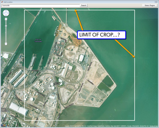
Guys, I've been playing with the 'Add location' function in SU and want to know if anyone has worked out a way to import a series of adjacent images to tile together over a large area.
My situation is that the site covers 17 kilometers and I am expected to produce an fly over animation of it.
Recently I was provided Geo-spacial data for a project of very high res photographs that were all able to just snap together in SU and match perfectly... What I was hoping to do was be able to 'grab location' via the Add location function and SU recall my last crop. That way I could snap to a corner and go again.....
Any experiences with this?
Maybe what is needed is a 'set crop size' to be able to bring in reasonably high res data into SU. You'll notice on the attached image that at around 3km up there is a white square that automatically crops to that selection even if you want to zoom out further which limits large scale aerial imagery from being exported. This makes it hard when this is what is needed and to do so you have have to extimate where the last crop was; how big it was, etc....
-
Well, this has been the pain of many lately. There is a tool which can make it easier to clip or trim adjacent (and a bit overlapping) tiles of the imported terrain mesh:
http://forums.sketchucation.com/viewtopic.php?t=40627but an ultimate solution would indeed be to somehow set it automatic.
-
Thanks Csaba, I'll have a look...
Hello! It looks like you're interested in this conversation, but you don't have an account yet.
Getting fed up of having to scroll through the same posts each visit? When you register for an account, you'll always come back to exactly where you were before, and choose to be notified of new replies (either via email, or push notification). You'll also be able to save bookmarks and upvote posts to show your appreciation to other community members.
With your input, this post could be even better 💗
Register Login


Advertisement