How to match a big horizontal building to GE´s terrain?
-
Ok, some doubts. In Harvey´s terrain editing, did he made a copy of the "GoogleEarth Terrain" or the "GoogleEarth Snapshot"?
I mean, if you make a copy of the GoogleEarth terrain, it makes difficult to delete a square out of it, even with TOOLS ON SURFACE PLUGIN, doesnt it?
GoogleEarth snapshot on the other hand would need to be transformed into a sandbox face before editing...
Or is it easier to just create a sandbox out of scratch and apply texture to it???
And from this comes my 2nd question... I just tried following Gaieus steps on the other topic. I then applied the color texture over the previously B&W Snapshot. Problem is, the new color texture is slightly out of place! While you can position it, I guess that exporting it back to GE, a millimiter difference in the texture positioning will create a break in the pattern!
Btw, I am trying to position the texture over the GE Snapshot and for some weird reason, I dont see the pins! When I try to editing other faces in the model, I can see the pins. Only in the snapshot I dont see pins when positioning the texture!
EDIT: actually, I found the pins. Noticed the pins are a few kilometers away... the GE color texture is repeated a dozen times in each direction before I can see the pins.
-
bah... Im ripping my hair off here...
ok, so I was able to correctly paint in color the GoogleEarth Snapshot.
But for some reason, the GoogleEarth Terrain got all black (in fact, same thing happened with the Snapshot, but I solved it by resetting the texture). Problem is, in the Terrain, because its not one but several faces (sandbox) I cant edit the texture! There is no TEXTURE option when right-clicking! And if I apply the texture again, it gets like this
and when it gets like that, I also cant get it right because there is no right button texture menu...
-
So when you painted the colour image on the snapshot (or actually, you shouldn't have painted it on the snapshot but reload the B&W image with the colour one) have you changed it to "Projected"? You have to go through these steps:
-
reload the image
-
unlock snapshot (best to unlock terrain the same time)
-
edit snapshot group
-
right click > Texture > Projected
-
sample image
-
edit terrain group and paint it with the projected image.
Or you can simply -
reload image
-
unlock terrain
-
edit terrain group
-
turn hidden geometry on (view menu)
-
right click on a (revelaed) facet on the terrain and
project the texture (like abopve) because NOW it will let you -
modify the terrain as you wish (I'd simply use the stamp tool from the sandbox for this in case of a rectangular building)
-
-
Ace,
When you upload your model to 3DW, include your new bit of Sandbox terrain. When you look at it in GE, you'll see that it all matches up and that the colors are correct.
Here's what I would do with you model:
- Copy the building model.
- Open a new SU page.
- Go to GE and get as close to the same scene that you had before as possible.
- Now here's the trick - In GE, click File>Save>Save Image. This will give you a color image of the scene in GE.
- With GE still open DON'T MOVE THE SCENE AT ALL! Open the SU window and click Tools>Google Earth>Get Current View.
- Now you have the GE Terrain and the Snapshot in the Layers menu. Paste you building model on the new terrain and use the Move and scale tools to get it exectly matched the new terrain. It shouldn't take very much adjustment as you tried to match you original GE view in Step 3. above.
- Save this model with a new name.
- Open the Snapshot from the layers menu and unlock it (right click>Unlock.)
- Right Click on the Snapshot group and click Edit Group to edit it.
- Use the Select tool to highlight the face of the Sanpshot. Then click File>Import and select your saved image from Step 4. above and apply it to the B&W Snapshot.
- Right click the image and click Texture>Position. Move each of the four pins to the corners of the Snapshot so that the color image precisely fits the whole image.
- Now you close the Snapshot group and save the whole thing.
- With the Terrain layer turned on, select the Group of your building and move it vertically so that the corner lowest in relation to the Terrain sits right on the Terrain and the other three corners float above it.
- Now use the Sandbox tools to build the new terrain flush with the bottom of the building and the edges just under the surface of the original Terrain.
- Use the Soften/Smooth Edges tool on the new terrain group.
- Open the Sanpshot layer and use the Paint tool to sample the Color snapshot.
- Still with the Paint tool, right click the new terrain group and click Edit Group. Click once on the new terrain group with the Paint tool and the color image should now be on the new terrain and, if you've been careful, it should match up with the original GE Terrain.
- When you open the moldel in GE, the terrain is in color so your built terrain will match.
Hope this helps,
Tom -
Ace,
In step 16. in my answer, to sample an image, hold the Alt key with the Paint tool and click on the image to be sampled.
Tom
-
thanks a lot. It did indeed help.
And I was able to export it to 3D Warehouse
http://sketchup.google.com/3dwarehouse/details?mid=47ffbeb07e53366bc5a01de21a4c6d88&ct=mdsato my dismay, while uploading from the browser only allowed KMZ files to be uploaded, now exporting through Sketchup, only Skp6 and Skp7 file formats were exported. And I dont even see the option to include the model for review for GoogleEarth 3D Layer, while when uploading from the browser in KMZ format, that option was present...
-
If your file is properly geolocated (either from SU 6 or 7), the upload process will automatically create the kmz file and all the related checkboxes and info fields appear. There must be something wrong with geolocation if they don't.
-
@gaieus said:
If your file is properly geolocated (either from SU 6 or 7), the upload process will automatically create the kmz file and all the related checkboxes and info fields appear. There must be something wrong with geolocation if they don't.
the geolocation is correct. If I export from Skp to GE (place model) it appears in the correct location in the world. But checkout my Mercado Público link... there is no KMZ there, only the two skp files...
tested uploading it again... still no luck, in the upload window there is no option to say the model "is real" and show be put to review...
-
Ace,
I downloaded the model from 3DW.
First, there is no Terrain or Snapshot layer in the model. So, it won't be geo-located when you upload it to 3DW. You have to keep the Terrain layer in the model even though it doesn't show in 3DW.
Second, uncheck the edges. You only need them when you're building the model. They look strange when viewing the finished model. Click View>Edge Style and remove the check mark next to Display Edges.
Third,Use the Soften/Smoothe Edges tool on the new terrain group. Right click the group, the chose Soften/Smooth Edges from the context menu. Check the box for Soften Coplaner and set the slider at something over 130 Degrees.
Fourth, go to 3DW and delete the model. Now with the terrain layer in the model, export it again to 3DW.
That should do it. Nice building, by the way. Porto Alegre looks like a niice town.
Tom
-
Sorry Tom, no luck. In fact, I had already added the terrain layer and tried uploading it again. Only difference was that I had not deleted the other model from 3D Warehouse before. Now I did it exactly like you said, deleting the model first, then uploading the model with the Terrain Layer... but as I said, no luck. Still no option to say the building is real and correctly geolocated, still no KMZ being created by 3D Warehouse
-
Can you paste the URL of the new one? (The old obviously doesn't work any more)
-
Hi,
OK, here's what I did: I downloaded you latest model from 3DW. Then I went into the Model Info window and chose the Location page. I checked the box "Use Georeferencing". Then I uploaded the model to 3DW at http://sketchup.google.com/3dwarehouse/details?mid=7c2cdad3f08176b63b1f82950a151c08
It looks like it worked because it shows correctly on the Map option in 3DW.I called it Temp and I'll leave it up for a couple of days then I'll delete it from 3DW
tom
-
So it wasn't georeferenced? (Sorry, I couldn't get to downloading it yet).
-
so it seems the "set geolocation" box got unchecked somehow (probably I did it by accident).
thanks for the tip. It worked flawlessly now. Btw, uploaded another building already!
My Porto Alegre Models
Ipiranga Tower
Receita Federal building
IPASE (Social Welfare Institute) and Public Market
-
Becoming ever more exciting.
One or two 3D model doesn't seem to make much difference but when there are a bunch in a close vicinity, it suddenly becomes interesting as you "start to feel" the mass of the city itself.
-
@gaieus said:
Becoming ever more exciting.
One or two 3D model doesn't seem to make much difference but when there are a bunch in a close vicinity, it suddenly becomes interesting as you "start to feel" the mass of the city itself.
I agree, and one of my first objectives at modelling Porto Alegre is to recreate all of the buildings in the Borges de Medeiros Av. "urban canyon".
-
I'm glad it all worked out. I've deleted the model in my section of 3DW.
I like the models together.
Tom
-
my fifth building, Espaço CIEE, located at 3rd Perimetral Avenue, Porto Alegre. You can two of my other buildings (Mercado Publico and IPASE) at the distance, a few km away, in the right.
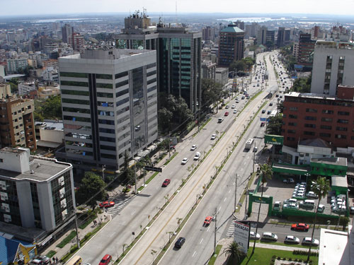
and here a photo of 3rd Perimetral Avenue, looking north (cant see downtown in this shot)
Advertisement