How do I import terrain
-
I am having a problem getting SU to import GE terrain and also to get SU to find its way to the 3DWH. I don't know how to set the paths in SU to communicate with either of these resources. I have looked at the tuts, but they assume you already have the proper paths set. So where do I start?
-
Roger, I dont remember ever haveing to set up "paths" to Google Earth or 3DWarehouse. At most you only needed to be logged in using your Goggle ID and password. Normally, if you are not already logged in and click on either "Add location" or "Get Models" on the Google toolbar, the login window would pop-up. Perhaps some screen-shots of what when you attempt these actions would help solve the mystery.
-
@sdmitch said:
Roger, I dont remember ever haveing to set up "paths" to Google Earth or 3DWarehouse. At most you only needed to be logged in using your Goggle ID and password. Normally, if you are not already logged in and click on either "Add location" or "Get Models" on the Google toolbar, the login window would pop-up. Perhaps some screen-shots of what when you attempt these actions would help solve the mystery.

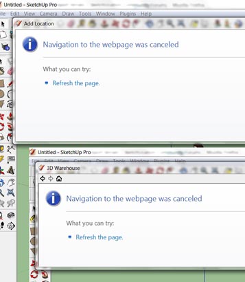
Here are the dialogs I get from "set location" and "3D warehouse". It does not tell you much. Hope this helps. -
What you have to make sure is to let SU communicate with the Internet. Under the firewall settings (or what) there is a possibility to allow or disallow certain apps.
SU needs internet connection to communicate with the 3D Warehouse (upload/download), the maps servers (location and street view imagery for texturing), for building maker - I think that's all.
You only need to log in to your Google account if you want to upload something to the 3D Warehouse (and maybe for BM, too).
-
@gaieus said:
What you have to make sure is to let SU communicate with the Internet. Under the firewall settings (or what) there is a possibility to allow or disallow certain apps.
SU needs internet connection to communicate with the 3D Warehouse (upload/download), the maps servers (location and street view imagery for texturing), for building maker - I think that's all.
You only need to log in to your Google account if you want to upload something to the 3D Warehouse (and maybe for BM, too).
Thanks to all. I now have my firewall settings straightened out.
-
And do the dialogs work now?
-
Yes, Gai thanks for pointing me in the right direction. Always good to have someone who can interpret the oracles that live in the dialog boxes.
-
After all this I find that either the vertical resolution is not great enough or suddenly my property has become much flatter.
-
The terrain (geometrical) resolution is also just as approximate as the snapshot image detailed. In some places, it's okay while it's better in others.
Are you sure you are toggling between (flat) snapshot and (3D) terrain though?
-
@gaieus said:
The terrain (geometrical) resolution is also just as approximate as the snapshot image detailed. In some places, it's okay while it's better in others.
Are you sure you are toggling between (flat) snapshot and (3D) terrain though?
The overall hill I live on shows, but the mound on my second lot show dead flat. Its just a matter of distance between contour lines. I need to get a smale scale topo map of the area. Or I may try to expand my experiments with 123dCatch to capturing topography.
Advertisement


