Plugin for importing large GE terrain areas into Sketchup?
-
Its very cool that Sketchup8 imports terrain already colored from GoogleEarth... however, there are several issues for users who want to make a model using a large area (lets say, you want the terrain around an entire town!)
1 - the maximum terrain area you can grab each time is very small
2 - unlike in version 7 (when you used GoogleEarth), you can not pan with arrow keys anymore, just with the mouse. Thus, sometimes, you wont get multiple terrain captures in a straightline
3 - every time you make a capture, when you go to add more imagery, the window resets to the original position of the FIRST terrain captured. therefore, if you must capture like 50 different terrains, its VERY VERY burdensome to reposition in the correct spot every single time you will capture a new terrain
5 - it captures every piece of the terrain with some Google logo under it. Thus, when making new captures, you must position the square not onl in the correct position, but also be careful to position in a way that the area without the logo, of the new capture, will be OVER the area of a previous capture that displayed the logo.
5 - it seems terrain still does not matches quite perfectly. You can always use Didier´s terrain remath plugin, but applying all the textures again is next to impossible if you are dealing with big areas...
Can a plugin be made to import larger areas from GoogleEarth, maybe even allowing the selection of "focus areas" (the closer you get to the terrain, the more detail Sketchup captures... you USUALLY dont need huge detail for the entire model...
-
I also wish there was a plugin like this. In fact, what I'd really like is to get the terrain pieces in perfectly aligned (so no overlaps - see comment on #5 below) as they could be much easier to stitch together at the end.
As for the logo (#5) - it would be against the TOS to hide/cover it if you use the imagery (I think). But actually any solution would be better than what we currently have.
-
The terrain mesh is generated from a tif image (elevation map). It's resolution depends on the zoom factor, the size of the selected area and the resolution of the elevation data on Google Servers. Because of that almost every imported terrain patch has a different mesh resolution or is at least slightly shifted.
-
Aerlilius, actually you were my hope. Don't disappoint me, please!

OK, let's assume we zoom in as far as that (expandable) square fits on the screen and only pan. What we'd need is to make sure to pan exactly much enough to match the two sides of that rectangular area (and of course, only pan in the x and y directions). Could that be done?
-
@gaieus said:
As for the logo (#5) - it would be against the TOS to hide/cover it if you use the imagery (I think). But actually any solution would be better than what we currently have.
what if you could have the logo only in the large image (total terrain, instead of every 200 meters (since several snapshots were captured)??
the TOS probably doesnt limit the size of the area in which the logo must exist... maybe it limits the size relation (lets say, if you capture 50x50 meters, the logo will be about 2 meters height... if you captured 500x500 meters, the logo would need to be 20 meters in height)
-
That's right but technically (if it can be solved), a precise alignment is better in case you really want to stitch those pieces together. And since the plugin could probably not influence the imported image (i.e. if it brings a logo in or not), it would be repetitive as you say.
Most probably a native, Google solution would be best (to somehow have an input box how big area I want to import regardless of what can be seen in my screen - say with the origin at where my crosshair is).
-
@gaieus said:
What we'd need is to make sure to pan exactly much enough...
 You are funny, the API has no method for that
And if there was a possibility, it would be a very ugly, evil hack ("Don't be evil"). But maybe some ruby scripter just needs to have a creative moment...
The problems to solve is:- we don't know the zoom factor
- we don't know the window size
- we don't know the size of the selected rectangle
- we can't evoke the "grab location" (the user would do it manually)

@aceshigh said:
what if you could have the logo only in the large image
We should be careful when interpreting the TOS. Several individual terrain patches consist of individual image files - and each one needs to have a copyright hint (probably Google has no specific rule for the distance where the logo appears, but rather it could be disallowed to remove the logo in any way).
-
When we grab a piece of terrain (or even before; when we select it), is there any way to tell the co-ordinates of the corners of that rubber band rectangle? (If not, any further discussion is futile of course but I was hoping).
Actually Vue can grab a GE region and then add a surrounding region to that (more detailed) central region and create an editable terrain this way. I just hoped that a "more native" (i.e. Google) application can do at least as much as a completely external app.

-
so VUE can import directly from GoogleEarth?? With the textures? And how big an area can it import?
-
No textures I guess (Guess!) as it would be quite different from what Vue is for. But maybe textures. I do not exactly know as I do not use Vue - we should ask Pete (I only read this in a tutorial or was it a video?).
-
I second!
It is almost painful that one needs to jump hoops to use GE with Sketchup. I use pretty good product with AutoCAD that works fine for the purpose intended (plex.earth tools from plexscape.com), so it should be expected that after purchasing SU8 Pro and GE Pro you should have tolerable work-flow. Even C4D has plugin.
-
@plex said:
I second!
It is almost painful that one needs to jump hoops to use GE with Sketchup. I use pretty good product with AutoCAD that works fine for the purpose intended (plex.earth tools from plexscape.com), so it should be expected that after purchasing SU8 Pro and GE Pro you should have tolerable work-flow. Even C4D has plugin.
being able to select a large area, and Sketchup automatically importing several pieces and mounting the puzzle should be a must. If possible, also select areas of "focus", so in those areas Sketchup will import smaller, higher res pieces. If possible, already drapping the most detailed pieces over the larger, less detailed ones, and joining the higher detailed terrains (more triangles) with the less detailed ones (less triangles), in the borders only, of course...
-
Im still sweating here... had to import like a hundred different pieces from GoogleEarth... and now I am having to CUT the pieces (because several of them overlap in some place or other). This is terrible... I use Zorro to cut the pieces but it is IMMENSE work!
-
I also miss a more advance plugin when it comes to grabbing terrain!
-
These are just ideas that came to mind as I read the thread:
I had thought that either TIG, or thomthom, or possibly Pixero had dealt with this issue and had come up with a "stitcher" of some sort? And it seems that maybe "brookefox" had discussed the same issue?
I did do a search in Plugins Index. Maybe my keywords weren't right. -
actually, after my requests, some interesting plugins were created that really helped me with my project. Too bad the threads arent linked...
but check here
http://forums.sketchucation.com/viewtopic.php?f=323&t=40627&hilit=terrain+meshhere are SdMitch plugins... check the Terrain Tools plugin, which is basically his two terrain plugins plus an extra function.
-
There you go. I did not think of using "terrain" an obvious keyword variable.
-
There was an application called Google Map Buddy which would automatically stitch together GE files to allow very high resolution images to be created from Google Earth. You would however have to import them and project them onto the terrain manually. Unfortunately Google took exception to it and made the software writer take it down (http://www.augmentedrealitysoftware.co.uk/gmb.html). It might still be available if you (ironically!) do a Google search though.
-
If any plugin wizard is bored without nothing to do, importing really large terrain areas (or automatically importing several small detailed areas) is a feature still missing on Sketchup.
-
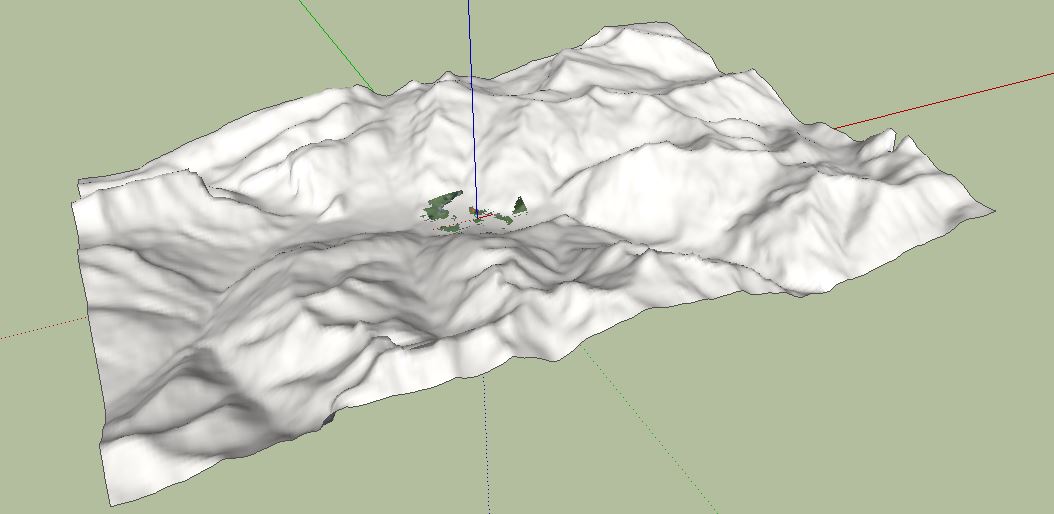
I just added a feature in Skelion plugin to add large terrain mesh. It uses NASA’s SRTM Elevation data. The bad news are that it is a pro feature and there is no good interpolation, so in some areas like Tibet you can appreciate the errors.
No image terrain imported.In the image you can see maximum area of SketchUp and the mesh exported with Skelion.
Hello! It looks like you're interested in this conversation, but you don't have an account yet.
Getting fed up of having to scroll through the same posts each visit? When you register for an account, you'll always come back to exactly where you were before, and choose to be notified of new replies (either via email, or push notification). You'll also be able to save bookmarks and upvote posts to show your appreciation to other community members.
With your input, this post could be even better 💗
Register Login


Advertisement