sketchucation logo sketchucation
    • Login
    ℹ️ Licensed Extensions | FredoBatch, ElevationProfile, FredoSketch, LayOps, MatSim and Pic2Shape will require license from Sept 1st More Info

    Procedural terrains

    Scheduled Pinned Locked Moved Gallery
    63 Posts 25 Posters 6.2k Views 25 Watching
    Loading More Posts
    • Oldest to Newest
    • Newest to Oldest
    • Most Votes
    Reply
    • Reply as topic
    Log in to reply
    This topic has been deleted. Only users with topic management privileges can see it.
    • soloS Offline
      solo
      last edited by

      lapx, I have not, sounds like the kinda thing I may be very interested in trying. got a link?

      http://www.solos-art.com

      If you see a toilet in your dreams do not use it.

      1 Reply Last reply Reply Quote 0
      • D Offline
        dudekracked
        last edited by

        hi lapx

        what is the height field ruby?

        1 Reply Last reply Reply Quote 0
        • D Offline
          davekn
          last edited by

          Hi Pete

          although this is off topic I had to reply

          Opened the forum today & was amazed to see a photo of where I live. Any reason you picked this area of Scotland or was it just random? Small world eh.

          Cheers Dave
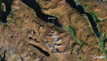

          scotland 1.jpg

          1 Reply Last reply Reply Quote 0
          • GaieusG Offline
            Gaieus
            last edited by

            Hi Guys,

            heightfield_gen.rb by Didier (scroll down to find it - I didn't want to link the ruby/text file itself).

            On another note, you may also be interested in the Cloud_V6 (i.e. SU 6) plugin also by Didier if you have a bunch of points (xyz coordinates) surveyed at a site.

            However all this you are doing here, Pete, is really impressing and awsome. I think even Google would be interested! πŸ˜‰

            Gai...

            1 Reply Last reply Reply Quote 0
            • soloS Offline
              solo
              last edited by

              Thanks Gaieus, I will look into them as soon as I am done current assignment.

              I did not know this ruby existed, brings me to the conclusion that i need to look into what is out there that may have been overlooked or older ruby's that could be more relevant now with all the added capabilities we have maybe there are some gems out there that could be better used now.

              http://www.solos-art.com

              If you see a toilet in your dreams do not use it.

              1 Reply Last reply Reply Quote 0
              • D Offline
                dylan
                last edited by

                This is fantastic.

                I think terrains are were a lot of us struggle getting good/accurate results.
                This could be a massive help to many.

                http://dmdarchitecture.co.uk/

                1 Reply Last reply Reply Quote 0
                • M Offline
                  mateo soletic
                  last edited by

                  Pete,
                  Great work.
                  I believe You started this thread in search of
                  information. Now we are left waiting for a tutorial. πŸ˜„

                  [Concept Illustrations](http://concept-illustrations.com/)

                  1 Reply Last reply Reply Quote 0
                  • L Offline
                    lapx
                    last edited by

                    Thanks for the assist Gaieus. I could never get that Heightfield to work with anything of significant size. This was some time ago, I gave up 😞 Maybe it's improved by now. It's in the right hands now. Here are some old links for more background:
                    http://groups.google.com/group/sketchup-Pro-Groups/search?group=sketchup-Pro-Groups&q=heightfield

                    1 Reply Last reply Reply Quote 0
                    • B Offline
                      bubbalove
                      last edited by

                      What would happen if you apply this technique to the Grand Canyon... that would be interesting to see....

                      "Success consists of going from failure to failure without loss of enthusiasm." - Churchill

                      1 Reply Last reply Reply Quote 0
                      • soloS Offline
                        solo
                        last edited by

                        I gave it (the hieghtfield ruby) a shot using a .raw and .ppm image of the Grand Canyon but after the drop box dialog appears nothing happened, no mesh nada, whats up with that?

                        http://www.solos-art.com

                        If you see a toilet in your dreams do not use it.

                        1 Reply Last reply Reply Quote 0
                        • R Offline
                          rsw
                          last edited by

                          Probably doesn't help much, but here are my thoughts on this...

                          One thing I notice from your experiments with GE images is that the end mesh is not accurate (in my opinion).

                          Particularly noticable to me is your first ge image of scotland. The lochs appear to have very steep sides, which may be correct in some instances, but also the lighter coloured area is a mountain (An Teallach I believe) but there does not seem to be much height difference relative to its surroundings as I would expect.

                          I assume that the mesh is generated by colour of the ge image??

                          ge/gmaps does seem to have detailed elevation data (google map showing part of the same area of scotland showing terrain with contours), but it doesn't seem like this can be easily exported.

                          I attempted extracting these contours with raster to vector software, but needed quite a bit of time to tidy up to be of use, although the end result seemed reasonably accurate, especially with the gmaps satellite image added as a texture.

                          I will keep an eye on how this progresses (particularly if you are trying to create an accurate model)

                          Richard

                          http:img.userbars.pl9819554.png

                          http:i158.photobucket.comalbumst106671GUAMDUDEAnimated---User-Green.gif

                          1 Reply Last reply Reply Quote 0
                          • soloS Offline
                            solo
                            last edited by

                            rsw,

                            You are correct the hieghts are not correct, I am battling to get good source images, the ones you linked above are much better and I will give that a go tomorrow.
                            I will keep at it to the point that I either succeed or a better idea comes from it.

                            Below I used a photo and tried the straight .jpg to displacement method, it is not accurate but still a pretty cool looking result.

                            http://img92.imageshack.us/img92/153/obamapiczr6.jpg

                            Source image

                            http://img90.imageshack.us/img90/4917/bammaog8.jpg

                            The hidden line mesh 67000 faces.

                            http://img65.imageshack.us/img65/6647/bamma1tq1.jpg

                            result.

                            http://www.solos-art.com

                            If you see a toilet in your dreams do not use it.

                            1 Reply Last reply Reply Quote 0
                            • B Offline
                              bcoleman001
                              last edited by

                              @solo said:

                              Fossa,

                              I would not say it's an artistic approximation but more of a primary image limitation, see the images I get from GE have shadows and the shadows are a very instrumental in getting the displacement map accurate.

                              Just curious, but have you tried using the Micro$oft Live Maps? They seem to have less shadows. Just click on the aerial button to get the image. http://maps.live.com/?mkt=en-us Just a thought.

                              1 Reply Last reply Reply Quote 0
                              • R Offline
                                rsw
                                last edited by

                                @solo said:

                                Below I used a photo and tried the straight .jpg to displacement method, it is not accurate but still a pretty cool looking result.

                                Definitely a cool result, and very interested in how you are getting from the jpg to the su mesh.

                                Had another go at extracting the contours from google maps terrain images, with the following result:terrain2.jpg
                                Tidying up and assigning heights to each contour is tedious for large areas but not bad for smaller sections. I used the contour maps from http://www.earthtools.org/ which are in metres rather than googles which are in feet. This says that these contours were generated from data, if we could find out how the contours are generated maybe they could be imported straight into su...

                                Richard

                                http:img.userbars.pl9819554.png

                                http:i158.photobucket.comalbumst106671GUAMDUDEAnimated---User-Green.gif

                                1 Reply Last reply Reply Quote 0
                                • P Offline
                                  pav_3j
                                  last edited by

                                  two words.

                                  thank you.

                                  pav

                                  Just won the 'Who is Least Competitive Championships' where trying to win will make you lose. Trying to lose makes you win which makes you lose. Not trying at all makes you lose which makes you win which makes you lose.

                                  1 Reply Last reply Reply Quote 0
                                  • R Offline
                                    rsw
                                    last edited by

                                    Another go at creating an accurate terrain and came up with this:
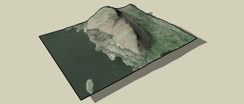
                                    terrain quick2.jpg

                                    Created this by using this site to create a 30x30 grid of lat, lon and elev data.

                                    Converted the lat/lon to UTM (meters).

                                    Imported into su with the points cloud ruby.terrain quick.skp

                                    Solo, I thought that using the srtm data with 3DEM to give images like thistest2.jpg and used with your method could produce some good results...

                                    Richard

                                    http:img.userbars.pl9819554.png

                                    http:i158.photobucket.comalbumst106671GUAMDUDEAnimated---User-Green.gif

                                    1 Reply Last reply Reply Quote 0
                                    • GaieusG Offline
                                      Gaieus
                                      last edited by

                                      Richard,

                                      This site uses GE terrain data, doesn't it? (at least to me it seemed so). What way is it better then than importing terrain from GE?

                                      Gai...

                                      1 Reply Last reply Reply Quote 0
                                      • R Offline
                                        rsw
                                        last edited by

                                        @gaieus said:

                                        This site uses GE terrain data, doesn't it? (at least to me it seemed so). What way is it better then than importing terrain from GE?

                                        It grabs the elevation data from usgs seamless elevation data sets, which includes SRTM data (among others) According to wikipedia GE uses srtm data and supplementary dem data to fill gaps. So that site does use very similar data to GE.

                                        As you will see from the skp below there is a difference in the geometry obtained from GE and from this site.terrain compare.skp
                                        The geometry from GE is lower detail - (unless you know how to improve this?)

                                        Anyway I was just experimenting to see what could be done

                                        Richard

                                        http:img.userbars.pl9819554.png

                                        http:i158.photobucket.comalbumst106671GUAMDUDEAnimated---User-Green.gif

                                        1 Reply Last reply Reply Quote 0
                                        • R Offline
                                          rsw
                                          last edited by

                                          @rsw said:

                                          (unless you know how to improve this?)

                                          Forget that, zoom in closer in GE and import into SU, then move along in GE and import into SU again, repeat until you've got the area you want (doesn't give a single terrain object and seems to import image as greyscale but is more accurate).

                                          Can't believe I missed that 😳

                                          Richard

                                          http:img.userbars.pl9819554.png

                                          http:i158.photobucket.comalbumst106671GUAMDUDEAnimated---User-Green.gif

                                          1 Reply Last reply Reply Quote 0
                                          • GaieusG Offline
                                            Gaieus
                                            last edited by

                                            Yes, I know this workaround but it will also give you rather clumsy results at the end when you try to stitch them together.

                                            It's actually a great feature in GE that the farther you are the less detailed everything is (otherwise it wouldn't be able to stream) but there should be a way (some option in SU) to import higher resolution terrain data.

                                            Interestingly, we have another discussion about this (and related stuff) in another forum with bjornkn & JClemens.

                                            Gai...

                                            1 Reply Last reply Reply Quote 0
                                            • 1
                                            • 2
                                            • 3
                                            • 4
                                            • 2 / 4
                                            • First post
                                              Last post
                                            Buy SketchPlus
                                            Buy SUbD
                                            Buy WrapR
                                            Buy eBook
                                            Buy Modelur
                                            Buy Vertex Tools
                                            Buy SketchCuisine
                                            Buy FormFonts

                                            Advertisement